Towards Designing with the Landscape Memory of Dutch Human-made Landscape
Abstract
This thesis explores how the concept of landscape memory can be translated into spatial and architectural methodologies for Dutch human-made landscapes. The study focuses on the Lek- and Rijndijk between Wijk bij Duurstede and Amerongen. Using this site as a lens, the aim is to understand where the cycles of construction, maintenance and adaptation create acumulations of memory. Through walking, writing, mapping, archival research and analysing case studies, much is revealed about landscape memory in practice, and in particular how it presents itself at the Lek- and Rijndijk. These insights were overlaid and analysed towards a methodological toolkit of eight approaches that support designers and spatial researchers in working with such landscapes. All eight methods have the goal of evoking a (re)connection towards the ever-adjusting sites that are Dutch human-made landscapes. The toolkit is not a fixed solution but a starting point that can be adapted to different contexts and conditions. This research demonstrates that landscape memory can be used as a lens for engaging with Dutch human-made landscapes as evolving environments shaped by both water and people.
“Landscape memory is seen in the behaviour of black-tailed deer in a recently burned forest, who come to prefer habitat less prone to high severity burns, the response of coral reef communities after a period of heat stress, and pine seeds which have evolved dependency on fire to germinate. […] Landscape memory encompasses a sprawling array of processes, from large-scale evolution to behaviours formed within single lifespans.”[1]
Chapter one: introduction
1.1 Personal Fascinations
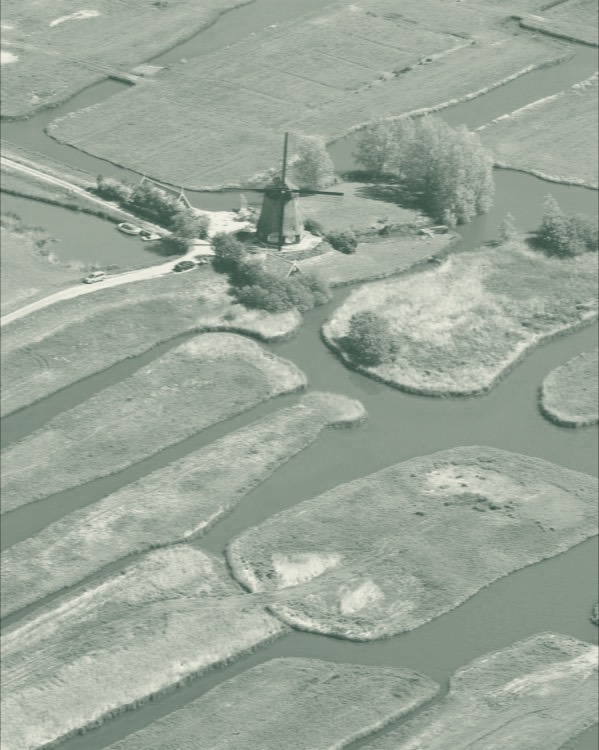
Growing up in The Netherlands brought a plethora of unique visual identities along with it. A windmill towering over the rivers, endless flat landmasses stretching beyond the sunset, looking for frogspawn under the creek’s bridges and biking past and over levees, bridges, canals and sluices. In Friesland, people leap over creeks with long vaulting poles. In Zeeland, massive barriers keep the sea from surging into its small neighbourhoods.
My family used to tend to orchard fields and ships in the harbour of Wijk bij Duurstede, a small river-side town in the Province of Utrecht. There, one Rhine off-chute meets another Rhine off-chute and their waters dance around each other, creating a beautiful interplay of soil and water, dynamic in every way possible. I used to ride the ferry to the other side as a child and no ride ever felt the same – the water seemed to bend differently, the trees rustled in an unknown tune, and the edges of the water seemed to change perpetually.
Fairly often, I had climbed the steep slope of the levee, always anticipating a new yet familiar view – but never had I considered the levee part of the play unfolding in front of me. I saw it, often, as a barricade, one ever-growing, tall and in my way. I’d often complain to my father how hard it was to bike up it, and how, when we had been sledding down it during winter, returning to the top felt like a chore. My dad would note the levee is there for us to appreciate, how it keeps us safe. As a child I didn’t understand what he meant.
I’ve noticed in my peers signs of a similar disconnect; high water hasn’t been an issue for most of us, despite the fact that our dwellings are built on ground well below sea-level. Of course, we’re taught about our past in history classes; how in 1953 the levees broke in Zeeland and hundreds of people and cattle drowned. Everywhere around us we hear stories and see parts of them: tall poles sticking out with a line indicating the level of a flood that had once been, a tv show speculating what it would be like if a storm surge enters the Netherlands in modern times. But never has my generation experienced a disaster on a scale akin to that of 1953, or any large-scale levee breakage for that matter; high water is not a threat to me as much as it is for my parents, and it likely isn’t the same threat that their parents felt growing up.
When I was talking to my father about how to approach this paper, we drove around the levee-system near Wijk bij Duurstede together. I told him, “I have not experienced a flood like that. Most of my peers have not experienced wet feet of that level, or a levee breaking.” To which my dad answered: “It’s something you’ll inevitably experience. The levees can be built but when the water’s too high, they will break. That’s anticipated. That’s accounted for.” Even with him instilling this in me, I didn’t feel scared. There’s been this disconnect I’ve felt towards levees and structures similar, and this disconnect is rooted in a lack of true understanding. Of the power water holds, but also on how careful we should be with the structures we depend upon. How can I connect to this landscape? And how can I harbour connection in a future where these structures keep growing, and keep changing, and keep extending the timeline towards inevitable failure? In what ways can designers interact with this landscape to revert this lack of understanding?
1.2 Problem Statement
All over the nation, the Dutch have found ways to both combat and embrace water. These interactions, in various scales, are shaped by a long history of human intervention in the Dutch landscape[1]. Safe from some rolling hills in the south and east of the country, rarely is soil left untouched by human hands or machinery. Cycling past a canal or walking across a levee means moving through a landscape that has been, and will be, ever-adjusted. Most of the country is an outlet, the delta, of multiple rivers[2]. The land sits low, often below sea level, and its layers are made up of mostly sand, clay or a mixture of both. The flexibility of the land is reflected in the way we’ve built upon it and feeds into this continuous cycle of adjustment. Despite its cultural and ecological significance, the levee is rarely experienced as a meaningful or lived landscape, and they are often taken for granted. Levees, polders, and flood control structures are generally not seen as constructed interventions, but as natural features: always present and functioning. The Dutch landscape cannot exist without them; they are a part of it and blend in with landscapes that already naturally occur. My own memories of growing up near a levee remind me that this “naturalness” is anything but. The slope I used to climb has grown steeper over the years, its surface hardened, its vegetation thinner. What is supposed to be a threshold between land and water has become a barricade. This levee, the Lek- and Rijndijk between Wijk bij Duurstede and Amerongen, is one example of what has happened nation-wide and continues to happen as the reconstructions of levees have started up again[3]. These changes are necessary and part of the reason levees exist in the first place: to protect us from the water beyond. Human-made landscapes like levees are there solely for function, but the more they are strengthened and pushed further into that role, the more they sever the connection between the water and the region’s inhabitants. The growth of these landscapes, their constant strengthening and reshaping, is part of why they are so easily taken for granted. The more they rise and obstruct the connection to the water, the more invisible their presence seems, even though they demand enormous effort to maintain[4]. This invisibility connects directly to the problem: people live with levees and polders without recognising them as needing maintenance, not acknowledging the work that keeps them intact.

fig. 2 sketch by author
Yet, a continued connection to these landscapes matters. Caring for them as something more than functional barriers acknowledges them as living structures, entangled with our own lives. In that sense, the relationship can be understood as symbiotic: the levees protect us, but they also depend on our care, our attention, and our memory to exist. Many Dutch citizens are largely ignorant of the full range of responsibilities held by the Waterschappen (Water Authorities) and Rijkswaterstaat, according to research done in 2022 by Citisens among over 14,000 respondents[5]. Despite the fact that every Dutch citizen pays an annual tax to the Water Authorities, the majority (60%) believe that their primary responsibility is to maintain clean drinking water – a task they do not supervise – while neglecting the crucial role they play in maintaining levees and waterways. The fact that only roughly three out of ten eligible voters cast ballots in the Water Authorities’ General Board elections suggests a general lack of knowledge and involvement with the system that keeps their feet dry.[6]
This lack of awareness points to an issue that lies beyond the numbers. The levee has become essential and its effectiveness has rendered it ordinary. As historian Petra van Dam argues, “the narrative of the Dutch as ‘water conquerors’ is a cultural construction, formed through selective memory and political storytelling rather than historical reality.”[7] This idea reduces the ongoing work of maintenance and reconstruction to a victory, something already won instead of a process that continues, and will continue into the future. As van Dam adds, “the idea that the Dutch ‘conquered’ water is a myth that obscures the ongoing and never-finished work of adaptation and maintenance.”[8] Because of this narrative, the labour and constant reconstruction that sustain the levee remain overlooked. The landscape appears self-evident, even though its stability depends on human effort. This then raises the question of how people can meaningfully relate to a landscape such as this: a landscape functional and familiar, yet unacknowledged as a place with its own memory. To close this gap, we need approaches that bring the memory of these human-made landscapes back into view. Understanding the levee not only as a functional, defensive structure but as a living landscape is essential for building a more attentive and reciprocal relationship with it. To achieve this, it is my understanding that one has to be in touch with its culture, ecologies and histories. The aim of this paper is to bring this perspective into focus, telling a more layered story of Dutch landscapes and showing how this approach can inspire design methodologies that work with human-made landscapes.
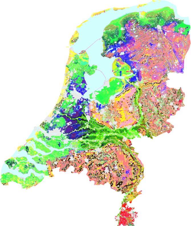
Chapter two: Research Questions and Methodology
2.1 Goals of my research
Using the concept of landscape memory as Ana Kilgore defines it,[9] the aim of this study is to explore how landscape memory can be actively translated into architectural and spatial design methodologies that connect people to the landscapes they inhabit. Dutch human-made landscapes are often approached through practical means: technical management and infrastructural planning, yet they also contain histories of culture: occupation, use, and adaptation that are visible in both physical and ephemeral forms. This research aims to understand how design interventions grounded in an awareness of these layers can influence and evoke connection. The intention is to develop a set of spatial design strategies that encourage a sense of memory and attachment, creating space for renewed appreciation of human-made landscapes such as polders and levees. These sites carry both ecological and cultural processes, which together shape how they are experienced. Rather than trying to get to a single solution or fixed outcome, the goal is to build an adaptive framework of methodologies, one that can accommodate nuance, uncertainty, and site specificity, allowing for layered and sensorial responses. There will be a specific focus on the Lek- and Rijndijk between Wijk bij Duurstede and Amerongen. This area has particular familial ties to me personally, and will serve as a case-study on human-made landscapes. Ultimately, this research aims to reframe design as a connector, mediator, and translator, actively listening and responding, positioning architecture as a method of engaging with layered human-made landscapes through attunement.
2.2 Research Question
In what ways can architectural and spatial design methodologies translate the concept of landscape memory to connect people to Dutch human-made landscapes?
2.3 Sub-questions
Sub-question 1: What defines a human-made landscape in the Dutch context, and how can we understand its landscape memory?
Sub-question 2: How can landscape memory be understood as both ecological process and cultural construct?
Sub-question 3: What existing methodologies align with the concept of landscape memory, and how do they evoke connection between people and place?
Sub-question 4: How can phenomenological and sensorial approaches to field research reveal the memory of the Rijn- and Lekdijk?
Sub-question 5: What methodological approaches can translate the concept of landscape memory into spatial and architectural ways of working with Dutch human-made landscapes?
2.4 Methodology
Taking the concept of Landscape memory as a starting point this research aims to explore how it can be translated into spatial and architectural design methodologies that connect people with the landscapes they inhabit, and the layers they are build out of. This paper will examine how design methods that acknowledge such layers can strengthen the relationship between people and their surroundings. The research is built up through three interconnected phases:
Literature Review and Case Studies
This phase forms the conceptual foundation of the project. It establishes a grounding in architectural, cultural-historical and ecological theory on connection and the Dutch context, an exploration of landscape memory, and how this all fits into evoking a connection to landscape. This feeds into the two case studies, through which relevant existing (architectural) projects are used to aid my field research through analysing applied methods.
Site Analysis and Field Research
In this phase, the Lek- and Rijndijk between Wijk bij Duurstede and Amerongen is explored through various embodied research methods. The landscape is studied on site through journaling, sketching, sensorial observation and mapping, and contextual, archival research. The goal is to document physical, cultural and sensory aspects of the landscape, and, through this process, understand its landscape memory and which aspects can be homed in on. Each method within this phase is based on work of other artists, architects or spatial designers. First, Richard Long, who informs walking-based research and intervention in landscape[10]. Then, George Perec influences my style of writing through observational notes in rapid succesion as per his book An Attempt at Exhausting a Place in Paris[11]. And lastly, Raoul Bunschoten brings to the table a visually striking manner of mapping, through which objects, interactions and natural influences can become part of a single image[12].
Reflection and framework building
Findings from the theoretical and field research are overlaid to build a framework of methodologies for understanding and engaging with (similar) human-made landscapes. This phase puts together insights from literature, case studies, and on-site experiences to identify tools for future design practices. Ultimately, this research paper positions design as a connector and translator between human and landscape. It proposes an approach grounded in observation and sensitivity to the sensorial, in which architecture becomes a way of understanding and working with layered, human-made landscape.
Chapter three: Literary Review
To understand how landscape memory can be used as a tool for design, it is necessary to first examine the existing knowledge that surrounds it, and what landscape memory means within these contexts. This literary review delves into three separate strands: first, how human-made landscapes in the Netherlands have been defined and theorised; second, how the concept of landscape memory can be understood as both ecological and cultural; and third, how sensorial and embodied experiences open ways of engaging with these layers. Together, these strands weave into the chosen case studies and inform the methodologies used during field research.
3.1 What defines a human-made landscape in dutch context and how can we understand its landscape memory?
Determining what landscapes are created by humans and what is a result of nature in The Netherlands appears to be a daunting task – most of the country, safe from some areas in the southern province of Limburg or the rolling hills towards Germany, have been uprooted, designed or redirected by the Dutch and their predecessors. Rarely soil is left untouched. As Mirjam van de Velde and Mieke van Dijk put it in their book Landschap in de Maak, “In geen enkel land is het landschap zo gekneed door mensenhanden als in Nederland. Dat ging niet in één keer, maar was een proces van eeuwen.”[13] (In no other country are landscapes as kneaded by human hands as in The Netherlands. This didn’t happen all at once, but was a process that took centuries). As long as the land has existed, and as long as it has been inhabited, it has been changed. Over time, human activity and natural occurrence became inseparable, creating a landscape where one cannot exist without the other.
Knowing this, to define human-made landscape, one first has to look at The Netherlands as a whole before delving into any specific site. The material foundation of the Netherlands already explains much of this continual reshaping.
The country is an extensive delta where several European rivers — the Rhine, the Meuse, the Scheldt — fan out toward the sea. These rivers intersect, change in width with the seasons, and tend to flood wide areas as large parts of the land sit below sea level. The soil is soft and mutable, composed mainly of clay, peat, sand or a mixture thereof — some textures fine, some gritty but rarely sturdy.[14] Peat bogs used to dominate much of the lowlands, they stored water but were also useful to dry out and then extract for fuel, which early settlers did eagerly. Clay deposits along riverbanks formed natural floodwalls due to their sticky, thick consistency, while sandy ridges offered slightly higher ground for settlement. This patchwork of soils and waterways made way for both risk and opportunity: areas that were fertile but unstable, habitable while in need of constant adjustment.
The Dutch landscape, as Mirjam van de Velde and Mieke van Dijk write, is “cultureel erfgoed, maar geen museumstuk,”[15] or a work in progress, an ongoing negotiation between water, the soil, and the people inhabiting them. Historian Petra van Dam describes how, before large-scale embankments became standardised, communities along the Zuiderzee and the major rivers lived in what she calls an “amphibious culture.”[16] Life in these low-lying areas required constant adaptation to tides, seasonal inundation, and shifting soil, and people shaped their routines around these phenomena rather than resisting them.
When approached from this angle, the Dutch landscape is unique in the way it is experienced both culturally and ecologically. One of the earlier authors touching on the negotiation between landscapes and their inhabitants would be Jac. P. Thijsse, an iconic educator on Dutch landscapes, waterways and ecologies. His book Onze Groote Rivieren from 1938 is a testament to the layeredness Van de Velde and Van Dijk describe. He vividly tells of the experiences of the levees, their being built, their presence and their inevitable breaks: “Wanneer we langs de dijken wandelen, ontmoeten we slag op slag herinneringen aan dijkbreuken, hetzij als eenvoudige plotselinge kronkeling in den dijk, hetzij in veel duidelijker vorm als wielen of waaien.”[17]
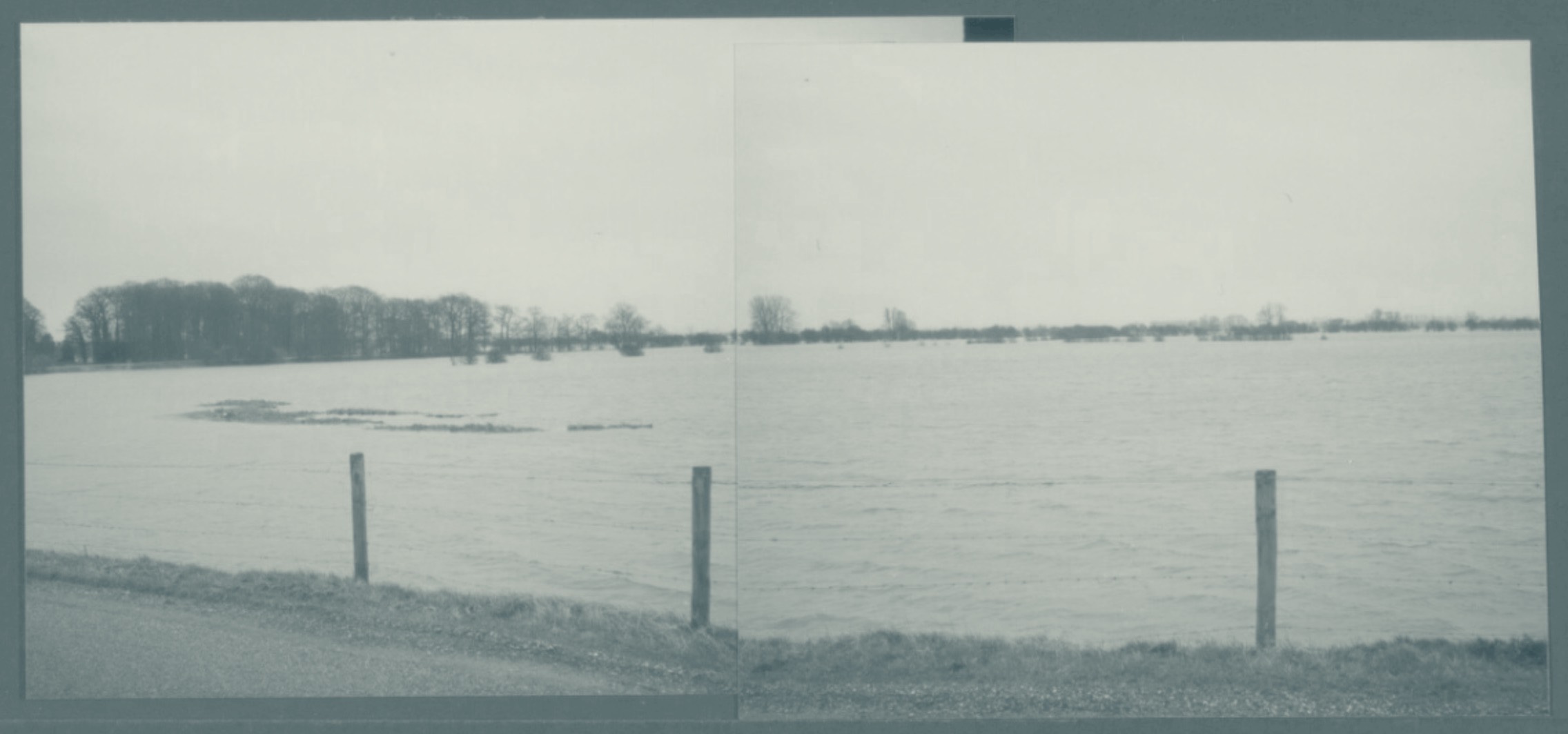
These floods, surges, and levee failures are deeply ingrained in local identities and memories, and in turn affect the landscape. The levees, following each tragedy, are reconstructed higher, sturdier, and longer. They carry dents and scars. Entire stretches of swamp are dug up and turned into flood walls. Entire livelihoods are up and moved. Reparations and ongoing construction define the area: it is a part of life, a rarely interrupted cycle. The memories cling to something ever-changing, so they dissipate in time. Where Thijsse describes indents and bends as scars, reminders of the battle, they have long healed over. Many “surgeries” have been performed to lessen this suggestion of the past. His accounts explain the Dutch landscape as a terrain in which human interference and natural processes merge into one continuous pattern of breakage and rebuilding.
Ton Lemaire’s Filosofie van het Landschap helps articulate this diptych. He defines landscape as carrying both natural and cultural meaning, writing that it expresses “een natuurwetenschappelijke [betekenis] … en een emotionele en meer esthetische,” and that in landscapes “onze cultuur en geschiedenis zich in al hun rijkdom en tegenstellingen … hebben geobjectiveerd.”[18] For Lemaire, landscapes mirror culture: they are products of control and progress, but also anchors of memory and attachment. Together, Thijsse and Lemaire underline the dual character of the Dutch landscape as a site of adaptation and remembrance.
A definition of human-made landscapes in the Dutch context must therefore extend beyond their engineering. They are evolving terrains shaped by water management and memory, carrying ecological processes, technical structures, and cultural practices all at once. They are lived-in sites of both continuity and change. Understanding them requires attention to both their materiality and their cultural heritage.
In this thesis, human-made landscapes are defined as those created primarily for human function: for living, farming, and maintaining safety. They are terrains designed to keep feet dry, secure livelihoods, and sustain communities but still function as a landscape capable of threading through, they symbolise a mixture of ecology and culture. Within this definition, I focus on three key types:
Terp or Wierde/Werve
Terps, sometimes referred to as Wierden or Werven, are artificial mounds constructed primarily in the northern provinces such as Friesland and Groningen. They are also present in areas where the Zuiderzee used to be before it was partially reclaimed. Originally, Terps were built to provide safe ground for settlements above flood levels before extensive levee systems existed and often held entire villages, including farms, churches, and livestock. They embody the earliest Dutch attempts to adapt to a wet landscape by elevating their dwellings rather than excluding water from them. Some are dated back as far as 500 BC. [19]
Levees or Dikes
Levees, or dikes, are elongated embankments made up of earth or stone, built to hold back water in various ways. There are three types of levees: Sealevees (barriers between the sea and land), Riverlevees (barriers between a river and land) and Inland Water retaining levees (barriers for smaller bodies of water, also used to surround lakes to drain polders). Levees can be found alongside almost every body of water in The Netherlands and are in need of constant upkeep to withstand rising water levels. [20]
Polders
Polders are low-lying areas of land reclaimed from water and enclosed by levees. Many polders were created by draining lakes, marshes, or parts of the sea, specifically from the Middle Ages and onward. To give an example, the entire province of Flevoland once was the sea-bed of the Zuiderzee, until it was reclaimed, laid dry, and the sea was reduced to the current linings of the Ijsselmeer. Polders are kept dry by drainage systems such as canals, sluices, and pumping stations, which are constantly running. They are primarily used for large-scale agriculture and to provide settlement, but their existence depends on continuous water management to prevent flooding. Without active pumping and maintenance, polders would eventually revert back to water. [21]
Other infrastructural elements such as canals, sluices, and mechanical works are excluded from this definition. While they are vital to Dutch water management, they are considered smaller-scale interventions or technical mechanisms rather than landscapes in themselves. These human-made landscapes form the foundation for understanding landscape memory within the Dutch context. Each carries traces of adaptation, resistance, and renewal that merge ecological process with cultural intention. Terps hold the memory of early settlement and survival above rising water. Levees bear the marks of centuries of construction, erosion and repair, shaped both by flood and human hand. Polders record collective labor and ongoing maintenance, where land must constantly be kept from returning to water. Together, they show that the landscape memory is not a fixed moment within Dutch heritage, but embedded in the continuous interaction between nature and culture. It exists in cycles of flooding and recovery, growth and subsidence, care and neglect. With this overlap, this mediation between ecology and culture, it then becomes the question what landscape memory means within the Dutch context.
3.2 How can landscape memory be understood as both ecological process and cultural construct?
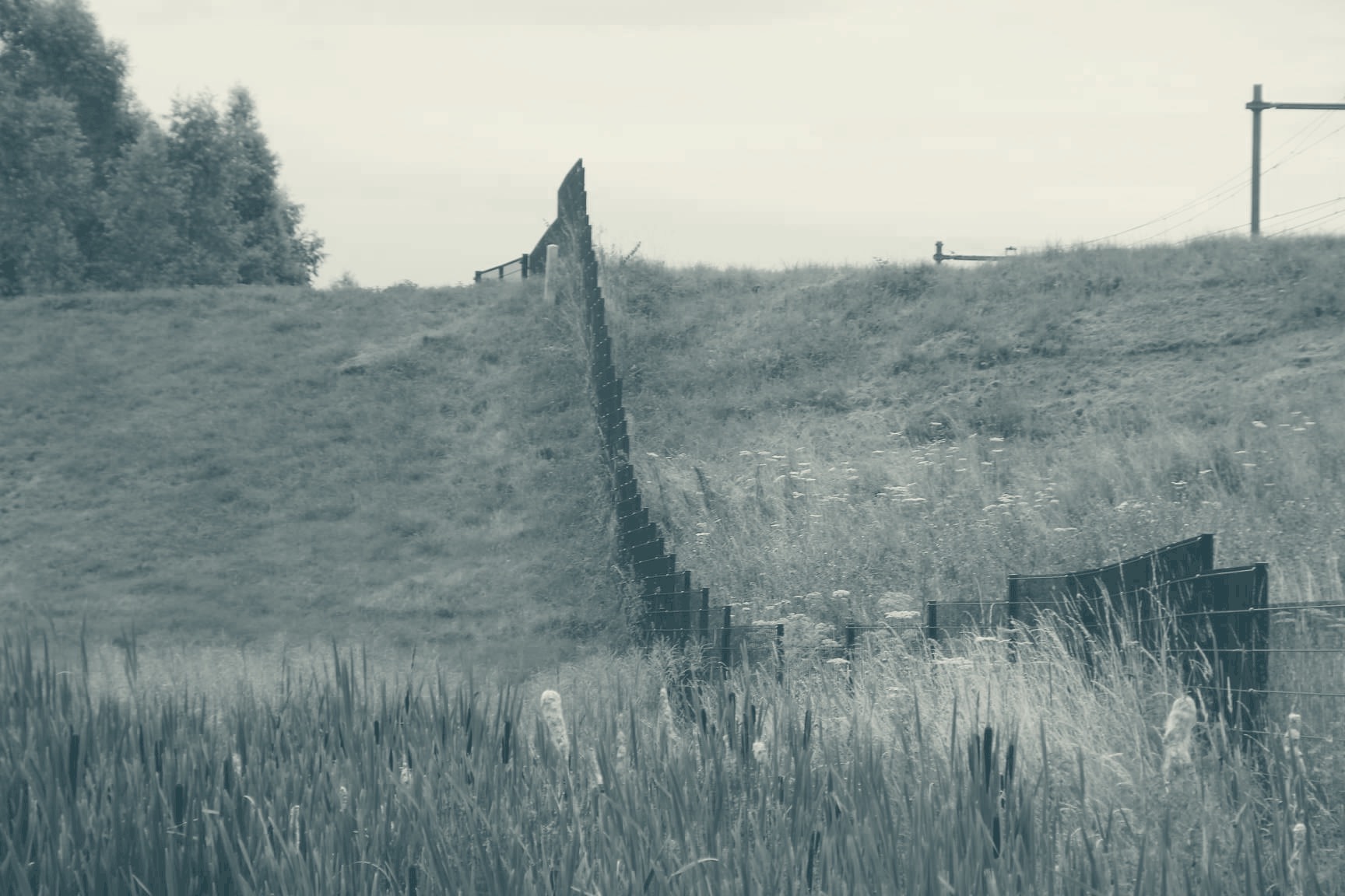
Landscape memory is originally an ecological term, understood within natural contexts: changes in weather, climate and natural disasters such as earthquakes, mudslides, eruptions or floods. Its initial scope is focused on how non-humans respond to non-humans, small- and wider scale, and the effects these responses have on the choices and evolution of all kinds of species. Their resilience and adaptation drive forward distinctness across a multitude of terrains. Nowhere in the original paper does the term landscape memory exclude human interference, but it does not name it either. If anything, the paper lays a foundation to be expanded — as Kilgore ends her paper with the following lines: “Exploring landscape memory reveals much beauty and many lessons, especially as it draws our attention to small scale, self-organising change, interrelation, and the way that the natural world remembers and adapts. Perhaps these lessons could help us locate beauty as we navigate the chaos of the other many overlapping, interwoven landscapes we find ourselves in today.”[22]
It is this interrelation, the overlap and interwoven-ness she describes that drew my attention to landscapes within Dutch context. Especially in landscapes that have been artificially erected, her concept can be extended to include human choice and adaptation, where the evolution of our own species becomes part of the terrain’s memory, and influences it in ways beyond natural occurrence. It is also the sense of exploration Kilgore puts forward, which can be overlaid onto landscapes like levees, terps and polders to understand their complexity through landscape memory. Kilgore breaks down landscape memory in four stages of an adaptive cycle — a generalisation of an otherwise vastly complex process. “We might enter this cycle at the stage of ‘exploitation’, where a relatively clean slate leaves room for growth. To use the example of a forest, young trees would sprout from seeds and propagules, building small communities. Competition intensifies during the following stage, ‘conservation’, and established residents block the growth of other trees and vegetation.”[23]

‘Release’ brings a disturbance, like a forest fire or a landslide, signalling a breakdown. Disturbances have a bad reputation, but defined simply, they are a release of built-up energy. After disturbance comes ‘reorganisation’, a period during which a landscape fosters new growth. Surviving aspects are central to regrowth, while that which does not survive is removed, or transformed into something useful. Familiar plants and animals return to a disrupted landscape, rebuilding as they have for millennia. When the cycle starts over again, it builds on a similar trajectory to the last. However, everything is slightly different: experience guides the way towards more resilient strategies. In short, each step can be interpreted as a pattern of build-up and breakdown, through which things are left behind or further embraced. When compared to Dutch Human-made landscapes, levees and terps specifically follow similar patterns within their existence. Each phase leaves behind its traces: ‘exploitation’ can be found within the initial act of building and claiming ground from the water; ‘conservation’ appears in the continuous maintenance, fortification, and monitoring of these structures; ‘release’ comes with failure, when water breaks through or floods in and forces a reset; and ‘reorganisation’ begins with repair, integrating new insights and technologies into the landscape. Whether structural, material, or habitual, each stage informs the next, with humankind as its driving force. In this sense, Dutch human-made landscapes embody both the resilience and forgetfulness that Kilgore describes. Their history of repeated construction and renewal mirrors the ecological logic of disturbance and regrowth, but it’s translated into a cultural counterpart: where rebuilding becomes a revisited ritual, and maintenance an inherited form of care. Landscape memory, then, is not only stored in sediments or vegetation but also in the labour, innovation in engineering, and belief systems such as fear and anticipation, that go into reconstruction of Dutch human-made landscapes.
3.3 Sensorial and Embodied Connections to space and place.
Now that there’s a basic understanding of human-made landscapes within the Dutch context, and how landscape memory feeds into it, it is now time to focus on what it takes to (re)connect to human-made landscapes, and what previously thought-of theory can aid me towards building my framework of methodologies.
Connection is a concept well-explored within architectural theory. The landscapes I touch on in this paper are not inherently architectural, yet those shaped by humans behave with similar intent. They are made with structure in mind, a function they carry out, and boundaries that guide the movement of its users. In Yi-Fu Tuan’s Space and Place, he distinguishes between space and place as two stages of familiarity. Space is open and defined as freedom, whereas place is what emerges through encounter and memory. He proposes that one can get to know a space, until it turns into place and goes on to name pause as a mode of creating place:
“Place is a pause in movement. Animals, including human beings, pause at a spot to establish a home. […] What begins as undifferentiated space becomes place as we get to know it better and endow it with value.”[24]
Juhani Pallasmaa extends this understanding of place into the realm of the body. He argues that perception is shaped through direct engagement, through being there and interacting with one’s surroundings sensorially: “We do not live separately in our skin; we live in the space around us. The body is the locus of perception and thought.”[25]
For him, knowing space is not a matter of seeing from a distance but of being, and dwelling, within it. Understanding comes from the senses being in contact with the world, from how light touches the eye, how sound folds around corners, and how the air moves against the skin.
This value Yi-fu Tuan speaks of is akin to the understanding of space Pallasmaa establishes; they are each part of the same spectrum that is connection. Connection, then, can be understood as a form of attention. It depends on presence and on the willingness to notice what often goes unseen: allowing yourself to know the direction of light, the shadows it forms and the subtle movement of the air around you. Sensing becomes a way of knowing, of uncovering the unnoticed layers and truly getting familiar with them.
There is also a form of connection that grows from knowing where a landscape comes from and what it has carried. Understanding the history of a place, or knowing how it will change in the future, can heighten my sensitivity. Historical knowledge perhaps prepares my mind to look more closely. It could give context to the small details and help anchor the sensory observations that follow. At the same time, entering a landscape without prior knowledge has its own value. It allows impressions to form freely, without the structure of expectation. Both states shape attention in different ways. Knowledge directs it, while not knowing opens it. For this reason, I let sensorial experience and contextual knowledge guide my field research alongside conventional methods such as archival work, and it will be conducted in stages: initially without historical knowlegde, and later with historical knowledge in mind. Together they help me learn the landscape from multiple angles and understand not only how it feels, but also how it came to be this way.
Chapter four: case studies
What existing methodologies align with the concept of landscape memory and/or how do they evoke connection between people and place?
Even when done unintentionally, landscape memory has been touched on by various artist, architects and designers throughout time. It is towards those instances I intend to look for initial clues on how to establish a framework of methodologies, as they can be analysed in real-time.
I set a few parameters before deciding on which sites I would pick out to do a case study on. First, the site had to be set within a relevant, preferably human-made landscape: something Dutch context-specific as established in the literary review. Second, there must be an element of human to landscape interaction; the site needs to be reachable by foot, and allow for a physical, sensorial experience. Using these parameters, I settled on two sites on opposite ends of the country: The Mosesbridge in the south-west of the Netherlands, and Terp fan de Takomst in the most northern province of Friesland. Each of these case studies will first be experienced, then reflected upon, and subsequently reviewed on what usable methodologies can be pulled from them.
4.1 Moses Bridge
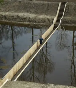
The Moses Bridge is located near Halsteren, in the province of North Brabant, and was designed by RO&AD Architects in 2011.[26] The bridge forms part of Fort de Roovere, a seventeenth-century fort within the West Brabant Waterlinie, originally built to protect the region from military enemies: it consisted of forts, ramparts, and inundation fields; low-lying land that could be deliberately flooded to stop invading armies. The idea was that shallow flooding would make the terrain impassable for soldiers and artillery, while still navigable for locals who knew the water. Looking from afar, the fort’s profile stays unbroken; the bridge merges into its surroundings, keeping the line between land and water as if nothing breaks it. As the architects note themselves
“The bridge is invisible from a distance, maintaining the historical profile of the fort and allowing the landscape to remain as intact as possible”[27]
Relevance
This site was chosen for two reasons in particular; the fort being part of smaller human-made landscape interventions in the form of water-defence structures and its cultural connotations, but also it‘s direct notion of interaction between the human visiting, and the site itself. The bridge directly opposes its original function, allowing what was once an “intruder” to walk across the waterbed through the structure. Its former role as a war device, pushing water forward as a weapon, has dissolved into something welcoming and reflective instead. The site’s relevance lies in the coexistence of these functions: the past is embodied in the shape of the fort, and the present is expressed by the bridge cutting through it. What makes this site particularly relevant to my research is how it transforms landscape memory into a lived experience. The bridge invites visitors to move through what was once a boundary. By sinking the path below water level, it alters how the body relates to the landscape while simultaneously recalling historical conditions. The visitor’s line of sight aligns with the water’s surface, allowing for a moment of partial submersion. It‘s an embodied reminder of this coexistence.
Embodied writing
It was a cloudy early morning in October – having just driven two hours straight, the cold air that met me as I exited my car was completely welcome. I‘m also met with an overgrown parking lot, which leads to a small sandpath through the grass. The land here is clearly altered by human hands; straight lines and sharp corners purposely put into shape. As I start walking down the path I bend some corners and cross a bridge until the higher artificial slopes surround me. It was quite a gradual walk, so much so that I question if I‘m in the right place. There‘s a black-clad visitor center to the left of me. It seemed closed, so I walk beside it and take a look at the map. The area I‘m in seems unassuming.
There isn‘t a whole lot around. Based on the map alone, I learn I‘m already amid the fort‘s structure. I start tracing the lines on the map and compare them to those around me, and suddenly the shapes start to make sense – the corners and lines together start to turn into the star-shape I‘m used to when looking at forts. Just up ahead, a staircase awaits me, and deducing from my newfound spatial understanding, it must be the entrance to the bridge. Next to the staircase, a desire path leads up the slope and I decide to follow that instead, hoping to end up on the side to get a different view of the bridge itself. I was fooled, however, as the desire path only lead up to a landing atop the slope, with a set of benches and providing an open point of view before one enters the actual brigde. Stepping closer, I gain a sense of submersion. The stairs down to the bridge are completely sunken into the ground of the slope, and the plants growing on it reach out far above the edges. To my left, a tower stands, another landmark meant to provide a different point of view, but it is not my focus currently. I descend down the steps and the sumergence becomes more clear as I reach the water‘s surface. Halfway down the bridge a puddle formed where the water breached the bridge‘s edge slightly, and when looking around me, it truly feels like I‘m in a sturdy, yet extremely fragile position. The water is at shoulder height for me, and my head pops out just above it. Almost suffocating when truly focusing on it, the water surrounds me fully apart from the straight corridor of wood right in front of me.
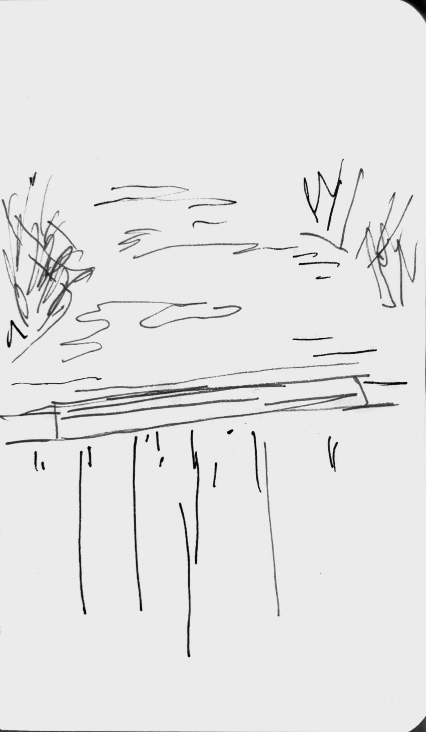
The cold breeze has also completely left, which surprises me. It‘s almost entirely quiet apart from the slight breeze brushing over the vegetation, my breath and my dull footsteps as I turn to look around me. It feels as though a wave can come and pull me away, despite the water being incredibly still. There‘s a lack of wrinkles and only further in the distance does the surface break into a million reflections. The grey clouds and darkened sky add to this dual atmosphere; of silence before the storm that never comes. It is in the middle of the bridge where I ponder whether the tower will add or take away from my experience, so I decide to leave it out of my visit entirely. I can imagine the bird‘s view on my own, and somehow it is not as riveting as the view I‘m getting now. I then wonder about this site‘s history, and the fact that this very moat must‘ve been used to bring enemy forces to their demise. They must have had a similar view, yet not as serene – instead they were likely panicked, fearing their lives, not dissimilar to this fear of a wave I felt earlier.
Soundmap
The Moses bridge is a pocket of quiet in the morning. The surrounding fort redirects wind and somehow, while amid the bridge, there‘s a serenity that can be felt. Only when listening intensely, noises start to reveal themselves. The rustling of the foliage, small bird sounds in the distance, the crinkling of the water and soft sloshing against the wooden walls.
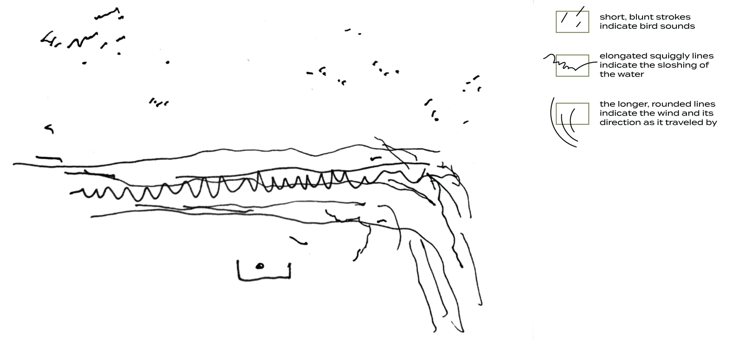
My visit to the Moses Bridge showed me how local memory can be made tangible through the act of moving across a threshold. Approaching the fort, the landscape appears unbroken and serene. I initially wondered if I had entered on the wrong end of the moat, but there‘s a slight linen when you look up towards the slope of the fort. Only when I moved closer did the bridge show entirely.
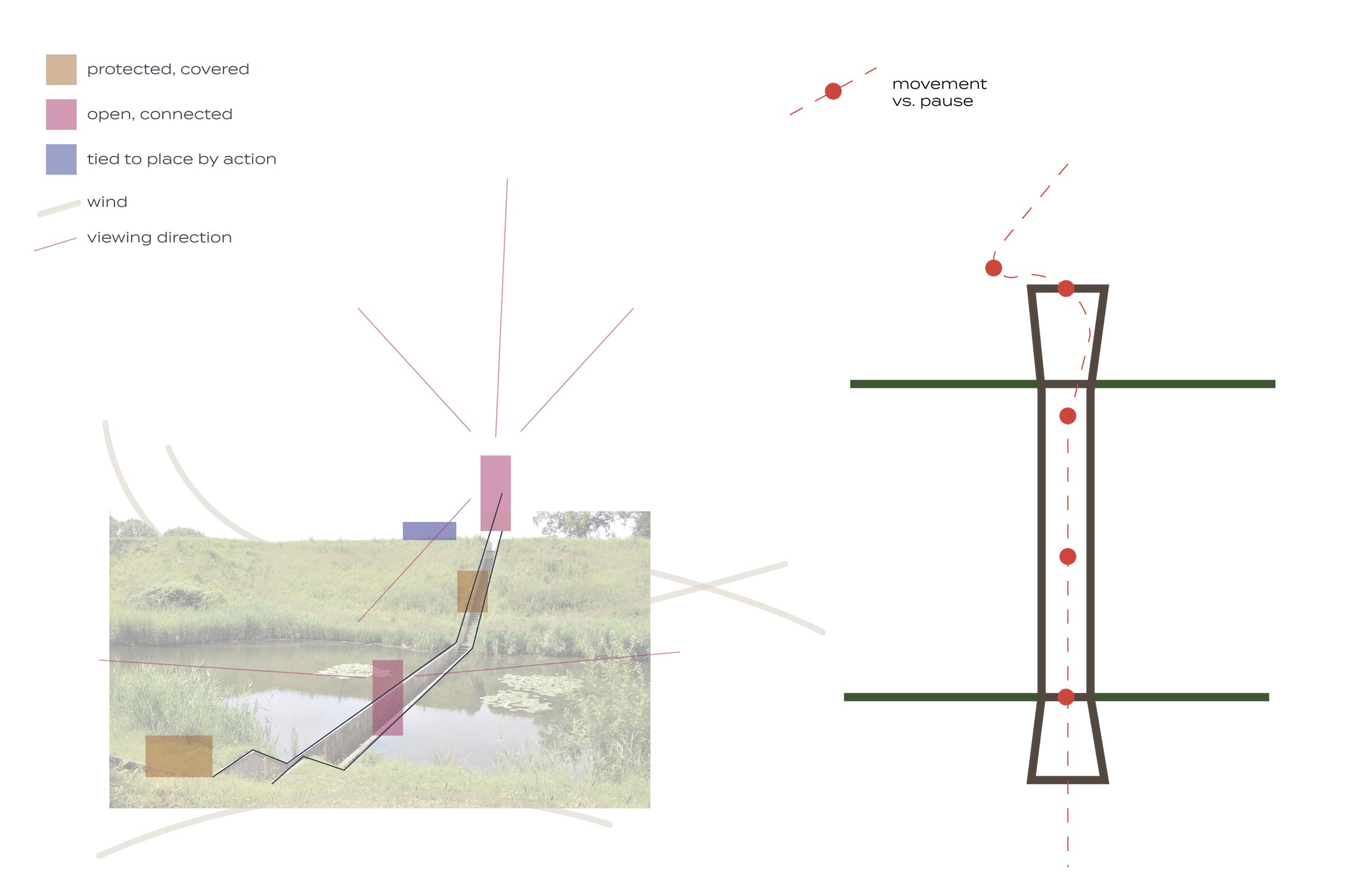
Walking through the bridge gave me a sense of being held between four sides. The wood beside me, a narrow corridor where sound behaved differently. Water became the clearest presence, while the broader noise of the landscape receded. The rhythm of footsteps softened, absorbed by the timber. The sky remained visible above, creating a vertical opening that guided sight upward while the body remained low within the water’s plane. This contrast of enclosure and openness shaped a layered sense of place.
The bridge reinterprets the historical role of the fort. Rather than pushing water outward, as the original structure once did, the bridge invites the visitor into the space where water was once a defensive tool. The experience becomes a quiet reversal. What was once meant to repel is now meant to be crossed. This movement through the landscape created a different awareness of the site’s layered past. Memory emerged not through explanation but through physical alignment with the conditions that shaped the fort’s history.
In this way, the Moses Bridge taught me that spatial design can reveal landscape memory through subtle forms of direction, immersion, and framing. It demonstrates how an intervention can both preserve an existing silhouette and transform the way the body understands it.
Directed movement
The narrow passageway that the bridge leads you down, coupled with the consistent height of the wooden walls, direct movement in a very straight-forward manner. They guide the pace, orientation, and sensory focus of the visitor. The only other way across the moat is to walk all the way around the fort, which makes the bridge both the most efficient and most sensorial way to cross. This gives insights on how spatial framing can influence how the landscape is perceived and reflected upon. By giving no other option, the experience is always met.
Submergence
The bridge hides within the original contours of the fort so that its silhouette remains unbroken. This approach preserves the historic profile while allowing a new form of interaction. The act of submergence already meets you at the entrance of the stairway down, and fills the space around you when walking along it. It‘s both vulnerable and powerful as the body is placed level with the waterbed – directly tying into the site‘s history. The act of submergence can, in this case, reveal the environmental and historical conditions that shaped this particular landscape.
A balance maintained
The puddle on the bridge, the still water, and the sense that a single wave could completey change the way I feel about this site all point towards a delicate balance of context. The site holds both safety and exposure. This balance perhaps offers a method for designing spaces that acknowledge the underlying uncertainty of human-made landscapes shaped by water.
4.2 Terp fan de Takomst
Terp fan de Takomst is a structure built outside the sea levees near the historic terp village of Blije. Blije is a town in northern Friesland, which originally lived with the sea in many ways; avoiding it by building terps, yet working with the tide to farm crops, extract fuel, reclaim land, and most of all bridge the gap between the mainland and the adjacent Wadden Islands when the tide is at its lowest, and the soggy sandpatches can be crossed by foot. Terp fan de Takomst was constructed by a combination of Observatorium Rotterdam[28] and Joop Mulder through his project named ‘sense of place’[29] on a quest to connect local histories to the people of Friesland, The plaque right outside the site tells us as much:
“The area was a life source for the people and a playground for the young. The expansion and raising of the seawall and the conversion of the area into a nature reserve meant that the Wadden Sea was no longer part of the daily life of the people, it severed the connection. In 2011 the people of Blije envisioned a reestablishment of this connection. “We want to live and work more with our gaze on the Wadden Sea.” describes their dream. The central element of this vision was to create a place of experience beyond the levee near Blije in the shape of a mound: The Terp of the Future. A place to tell old stories and create new ones. A place to be and enjoy.”[30]
Terp fan de Takomst is inaccesible four months a year due to the breeding season of multiple bird species in the area, but even outside this season, only when the tide rolls back out is the structure reachable.
Relevance
This particular site touches on a lot of themes relevant in this paper; local histories, human-made landscapes and an attempt at (re)connection between the people and said landscape – setting the scene for interesting insights. It brings the terp, one of the earliest Dutch strategies for living with water, into the present day, reinterpreting it as a space of reflection on local identity. Through the use of structure, shape and written word, Terp fan de Takomst reopens dialogue between people and the land they inhabit through spatial and sensorial experience, essentially bringing landscape memory into collective consciousness. In short, a site like this is already doing a lot of the things this paper proposes, and is therefore a valuable resource to learn from.
Embodied writing
On a sunny day in September, around four in the afternoon, I parked my car near a road up the sea levee in Blije, Friesland. After passing through kilometers of farmland, the edge of the land is reached, and it’s a big, artificial slope that keeps the high tides from seeping into the nearby homes. Beyond it, though not visible from down where I parked, there’s more land, but only for a few hours a day within specific seasons; kwelderland, or salt-marshlands. I walk over the cattle grid and onto a small, private road up the levee, where the sun blinds me for a minute before my eyes adjust to the vast stretch of land ahead of me.
The asphalt beneath my feet announces itself loudly with every step as I walk down the levee on the other side, and circle along with the road towards a decorated fence. Around me, the fields are filled with sheep, horses, a mix thereof, or simple, flat grass. As I reach the fence, a plaque sits besides it, and I read it. The carved granite tells me of the area’s history with terps, artificially built hills made to live on top of, entire townships and livelihoods dependent on them to keep their feet dry, and how their functions have seized since the levee I just climbed had been built. To honour the area’s history, Terp fan de Takomst has been erected amid the salt marshlands. I look in the distance and see the structure; its wooden beams and artificial hill stand out against the long, flat stretch of land. The land seems endless, but also so intimately time-sensitive; the knowledge that, in a few hours, the tide will rush back in looms over me. There’s no time to lose, yet the land itself somehow seems stuck in time all the same. I push the heavy gate and it croaks open, allowing me entry onto the grassy path. It closes behind me loudly- I have now committed to the trek.
The grass is firm yet malleable; it doesn’t sink with my feet but it does feel as if I could mould it if I stomp hard enough. The stream next to me slowly trickles by, the water low, the soil below cracked in patterns likely caused by a play of de- and rehydration. A few plants stick out above the surface. To the right, there’s a low electrically charged fence keeping in a flock of sheep, who cautiously watch me trot by while I watch a flock of birds overhead.
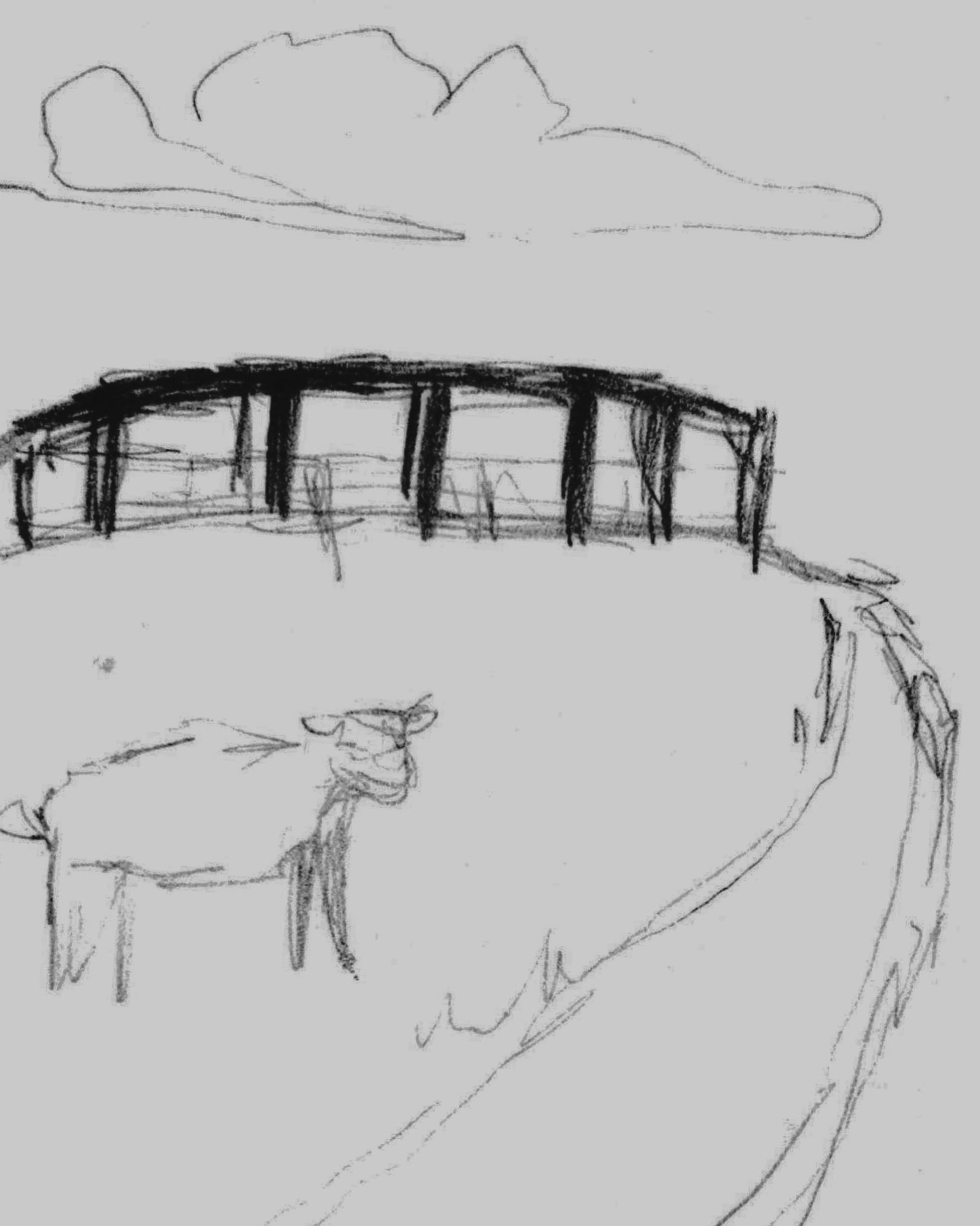
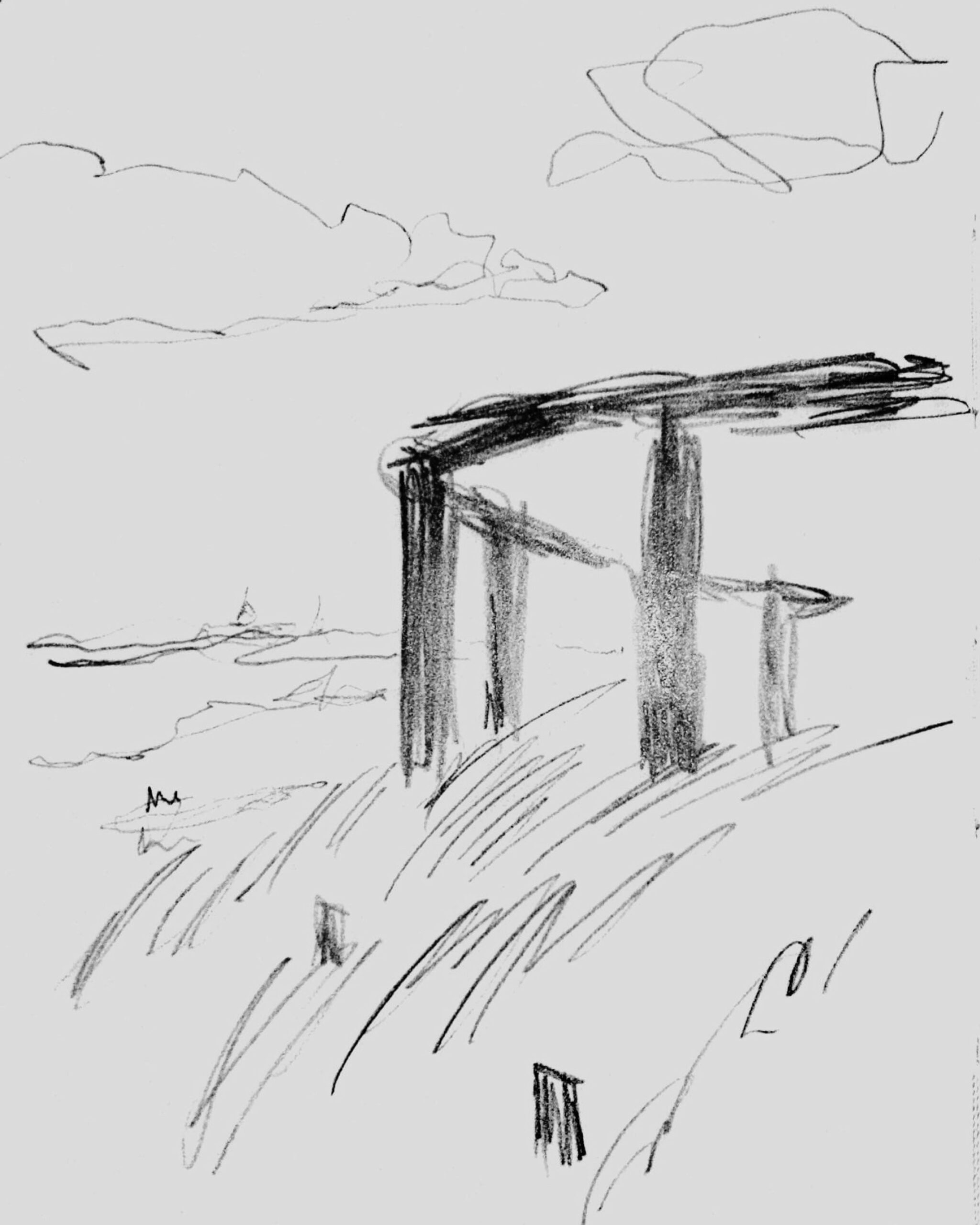
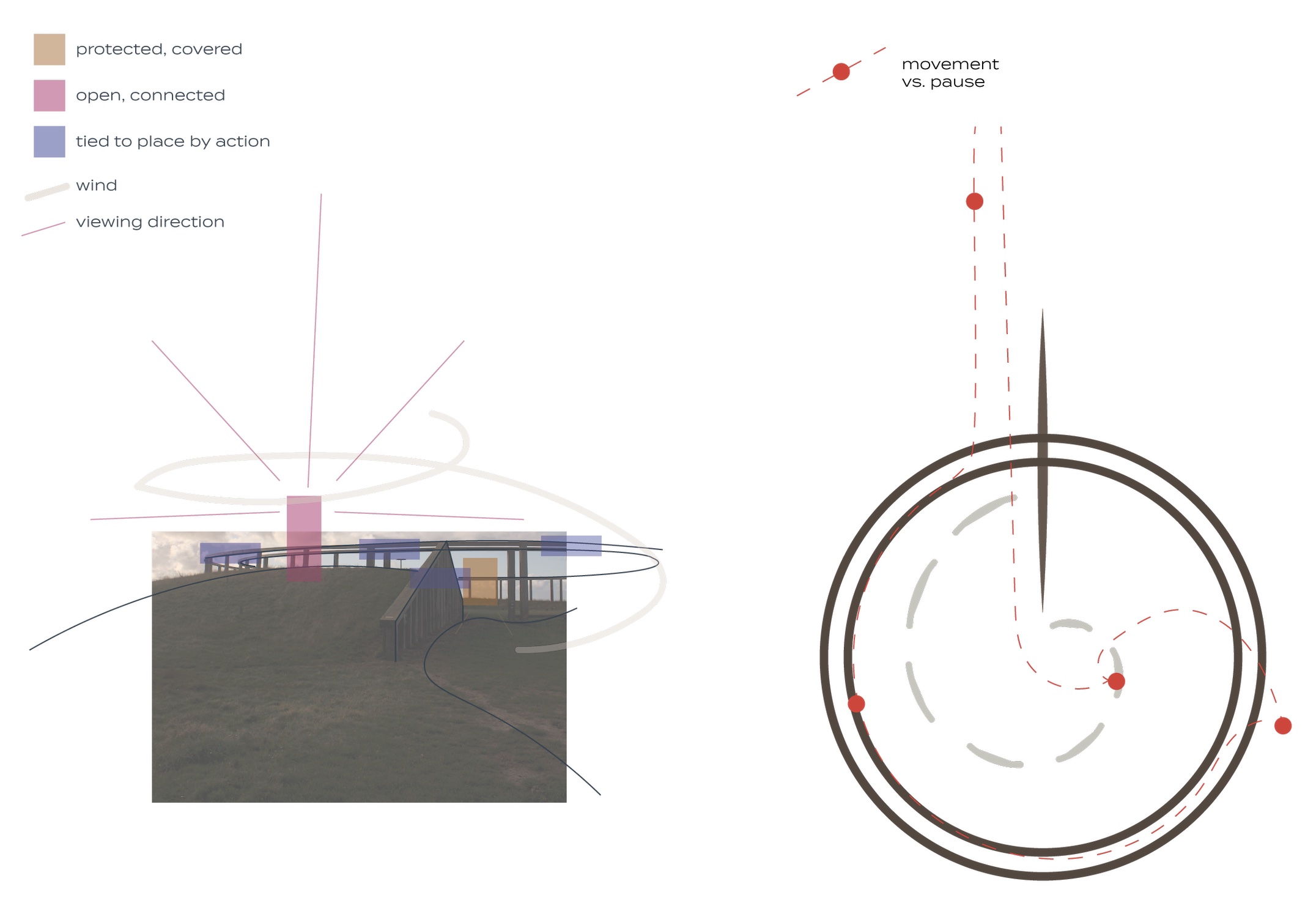
I climb a low, smaller levee, and am met with the second and then third fence; the latter of which leads into a wetter field inhabited by even more sheep. Small streams line out the pathway that leads to the Terp; a straight line in an otherwise bendy landscape. As I get closer, the denser the sheep flock becomes: they seem to gather around the Terps’ curves and the shade its structure provides. When I reach it, they all scramble; my presence seems unwanted by them, yet invited by the structure. The beams stand tall when I first enter the Terp; they tower over me and surround me through two parallel circles, built next to one another. The outer is adorned with a poem. The inner serves as a compass; each letter corresponding with a cardinal direction, firmly placing you amid them. In the middle and around the outer ring long, rounded benches have been placed, as well as small poles with name plaques. A path between the two rings leads you up the winding Terp, its hill increasing while the wooden poles stay the same in length. Halfway through, you stick out above the wooden structure, and watch out over the entire area outside the levee. In the distance a tractor drives. To my left, horses run in light of the lowering sun.
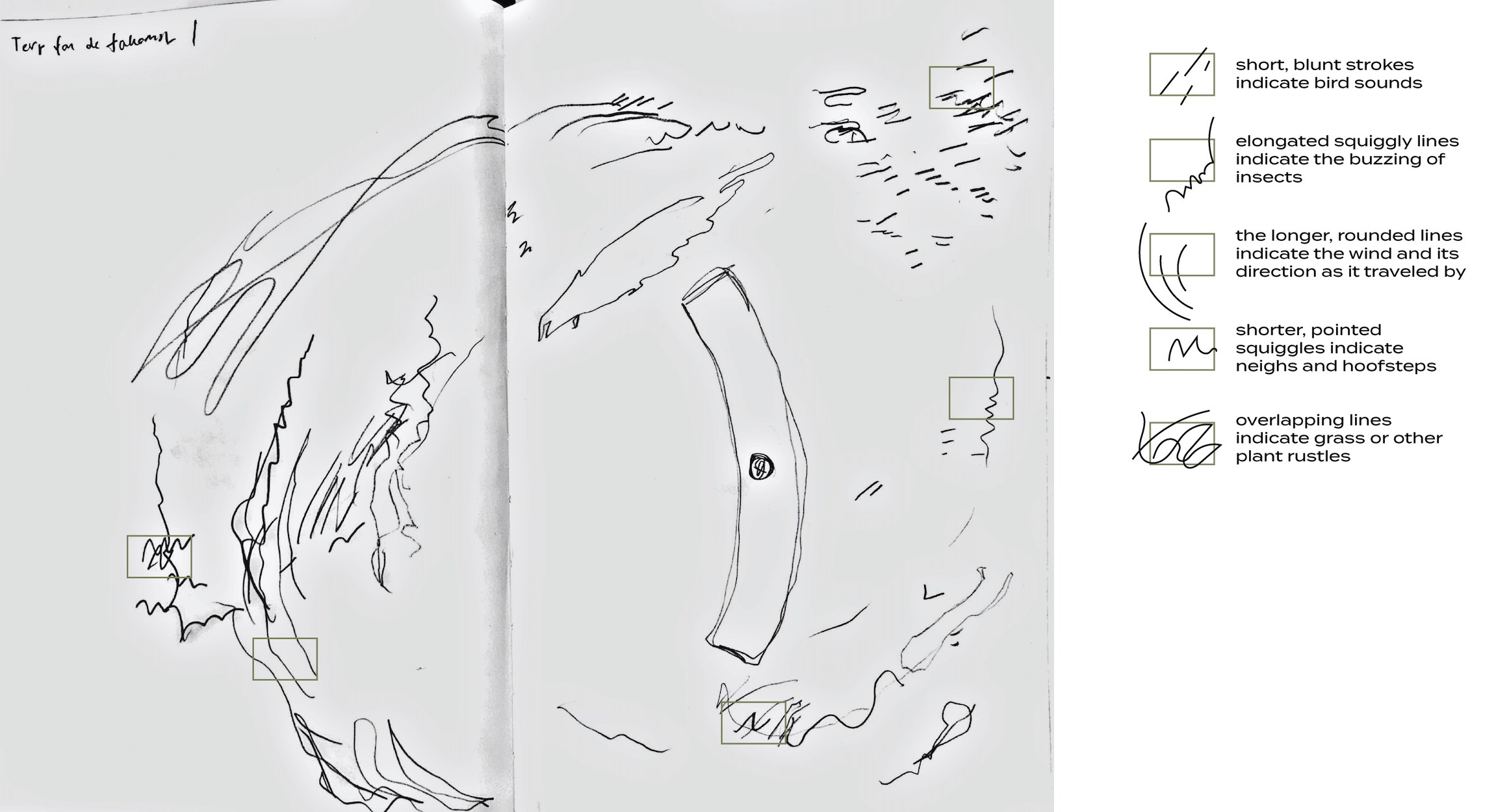
Soundmap
Terp fan de takomst sits in an overwhelmingly quiet area; the wind truly overtakes here but the site plays with its direction. And in the brief moments it settles down, there‘s an array of other sounds that make themselves known. The buzzing of a bee, the swallows, crows and seagulls chattering over one another, sometimes a horse neighs in the distance or you can hear the hoofsteps of the sheep roaming the meadow. Then, even quieter, right before the wind picks up again, the grass begins to whistle its tones, and just beyond it, the slightest trickle of water before the woosh overtakes again.
Reflection and take away
Terp fan de Takomst is a site in which memory and collective heritage are inseparable from the landscape it is placed within. It brings forward a history of living directly with the water, a way of life that has faded since the rise of the sea levees. The structure does not recreate the past in a literal sense. Instead, it brings the conditions that shaped it back into awareness. The tide continues to rule the land surrounding the terp, creating a sense of inaccessibility and anticipation that echoes the earlier forms of dwelling. The arrival of the levee protected the nearby villages and allowed for stable living conditions, yet it also obstructed the tidal landscape that once defined this region. Walking toward the terp made this more apparent than the structure alone. The progression from farmland to climbing the levee and then down into the marshland, temporarily filled with grazing sheep, felt like a slow reintroduction to a logic now lost. This manner of approaching created a gradual change into the region‘s past. The walk, in a way, allowed the past and present to fold into one another before I had even reached the actual structure. The spiral path up the terp truly grounded this experience. As the ground rose, the wooden structure remained steady in height., allowing my body to appear above the beams and gain a broader view of the surroundings. The inner circle felt intimate and protected whilst in it, hidden from the wind and protected from the harsh sun. Inside, two things could be read. One was the cardinal directions, which grounded me in place, and the second were lines of a poem dedicated to the landscape and its heritage, grounding me in time. Moving back up, the outer circle brought me back into the open. It reconnected my body to the expanse of the salt marsh. From my experience, there were four methods I was able to extract for further analysis.
Gradual introduction
The route toward the terp becomes part of the design experience. The slow transition from farmland to levee crest and then down into the marshland prepares the visitor to sense the site with greater attention. This shows how the approach path can introduce the landscape’s logic before the structure is reached.
Tidal rhythm and seasonal inaccessibility
The salt marsh surrounding the terp is shaped by tidal patterns that determine when the site can be approached. This creates a natural pause and encourages active engagement with the environment. It demonstrates that temporal conditions can be used to reveal landscape memory and to bring ecological rhythms into spatial experience.
Play of height
The spiral ascent uses elevation as a way of shifting perception. The inner circle encloses and steadies the body, while the outer circle expands the horizon and reconnects the visitor to the wider tidal landscape. This shows how height differences can create layered encounters with place.
Cardinal directionality
The carved letters inside the structure orient the visitor and situate the body within the larger landscape system. The directions work together with the poem to anchor the visitor in both place and time. This suggests that orientation can be integrated into design as a grounding element that deepens spatial awareness.
Chapter five: Field research of the Lek- and Rijndijk
5.1 Understanding the landscape through a phenomenological approach
Phenomenologically understanding my site, or simply put, trying to find ways to feel it, breathe it, eventually weave with it, means I have to be open to being in touch with my chosen location often, for prolonged periods of time, and approach it from different angles. Based on what I’ve learned through Yi-fu Tuan and Juhani Pallasmaa’s theory, I have to let perception unfold through my own body: I needed to be there, within the site, and experience it.[31] I am personally very sensitive to sensorial input; I have always had the ability to sense deeply, to sense the unnoticed, and then gain some understanding from doing so. Thinking about how I can approach the site in these manners, my goal was to write and draw, during walks or standing still: to use my body and my thoughts and express them. Through this process, I aim to gather insights that are felt first and analysed later, reflectively, to allow the landscape itself to guide how it wants to be understood. I have picked out three vastly different ways of approaching the Lek- and Rijndijk, and partially my case studies before this. Each approach is meant to give me a different angle, an alternate way of getting to know the landscape thoroughly and deeply.
Methodical walking
Walking has been a method I’ve been exploring for years, and is heavily influenced by Richard Long’s body of works. A Line Made by Walking, a work of his made in 1967, is as simple as it is not. The picture depicts a straight line, a beaten path, in a field. Its rigid shape contrasts that of the surrounding nature and stands apart. Richard Long oftentimes makes temporary sculptures on his walks by rearranging found materials, and other times he simply records his paths through maps or images.[32] Similarly to him, I intend to use walking as a method of exploration and open-ended knowledge gathering: things I find, people I speak to, or simply looking back to where I have and haven’t been; through walking I will gain insights that I would not find by driving my car over the road atop the levee.
Writing like George Perec
George Perec is a French novelist, filmmaker and playwright who was known for his explorative writing works. The text I’ll be referring to within this paper is one of his later works, An Attempt at Exhausting a Place in Paris, which is a 60-page book in which Perec writes on the movement of people and things within spaces. He focuses heavily on noticing both the big and small things. As stated on one of the first pages: “What happens when nothing happens other than the weather, people, cars, and clouds? What can be said, what can be noted, what can be written, when all that happens is the passage of time?”[33] What follows is a script-like 50-ish pages, in which he states everything unfolding in front of him through a manner of repetition. His observations come one after the other, often with the same sentence structure and a lack of punctuation. There’s a certain rhythm to it that paints a vivid picture of his surroundings.[34] By writing down my own experiences in the same manner, I intend to figure out what it is that moves through the Lek- and Rijndijk, but also create a foundation I can refer back to. I will create what is essentially a logbook, on different days at different times, of my selected site.
Mapping the noticed and unnoticed
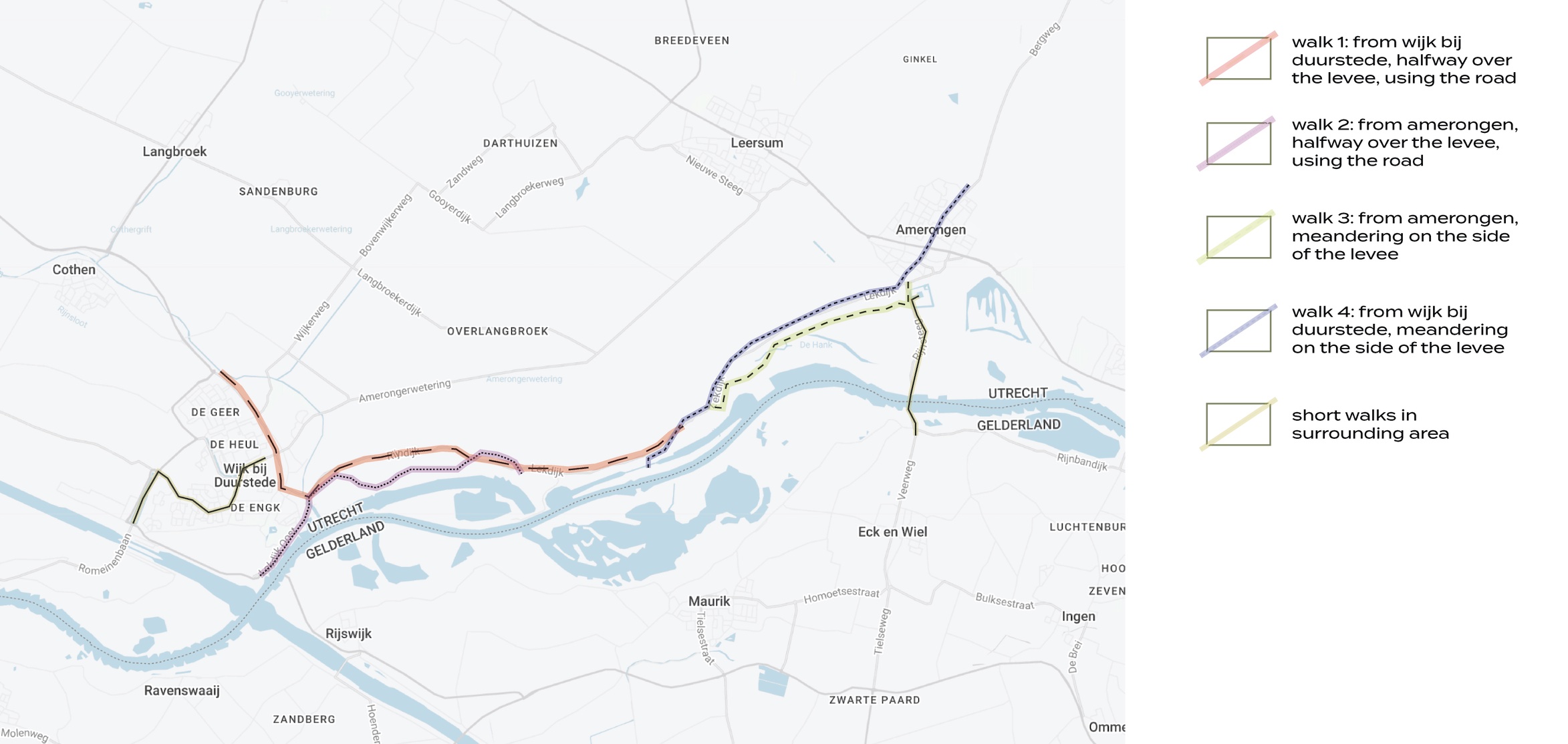
The mapping approach I used was informed by Raoul Bunschoten’s idea of framing. In his book Urban Flotsam, framing is a way of visualising what is overlooked. He writes, “Framing exposes relations that otherwise remain concealed.”[35] and: “A frame is not a representation. It is a tool for thinking.”[36] Framing encouraged me to look at the levee through multiple lenses at the same time: a walk can reveal movement and atmosphere, but mapping allowed the things I noticed to be separated and studied more closely. Marks of erosion, the direction of wind, repetitions of movement, and changes in the textures under my feet each became individual frames. By isolating them, can I outline that what makes this landscape unique?
5.1.1 Methodical walking
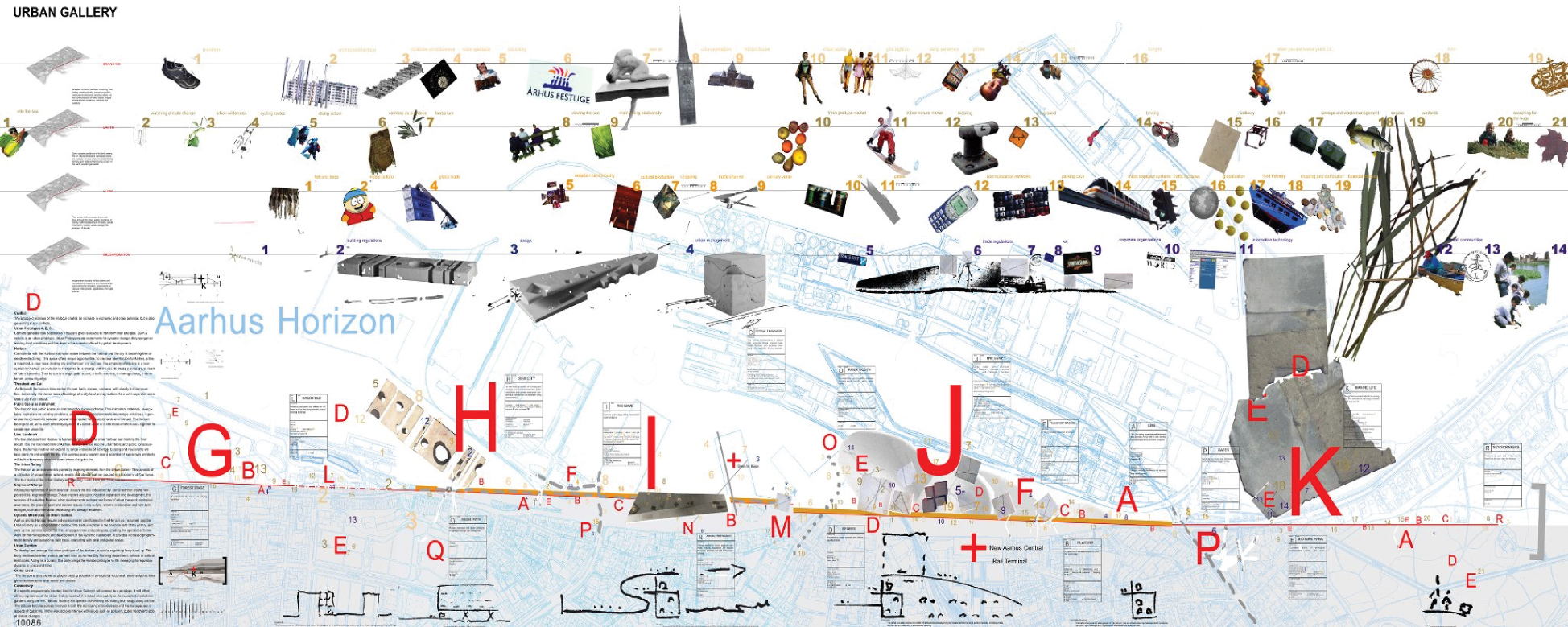
Walking as a method, initially inspired by Richard Long’s A Line Made by Walking, has been the carrying force throughout experiencing the Lek- and Rijndijk. To understand the levee through my own movement, I structured my field research around four separate sixty-minute walks, each guided by a different instruction. The walks were not just a way of crossing the landscape but also a way of comparison. By repeating the act of walking along the same stretch, changes in the surroundings became present.
The first two walks were designed to follow the levee according to its existing rules: following the road and not crossing any boundaries. I began one walk from Wijk bij Duurstede and the other from Amerongen, moving toward the same midpoint from opposite directions: the Stuwwal. Both were carried out along the road atop the levee, keeping to its assigned route.
These two walks were dominated by a sense of alignment and orientation. They allowed me to understand how the levee was intended to be moved through. At least, partially, as walking along the road felt unsafe at times when cars rushed past – there‘s no formal footpath and I walked along the bike path instead. What did aid me was the steady elevation, the constant view over the floodplains, and the presence of others passing, giving me insights on the traffic that moves through here regularly.
Walks three and four were meant to steer clear from the established rules. I intentionally left the main path and moved along the sides of the levee, following smaller tracks, grassy slopes and crossing some low fencing. This allowed me to experience the levee from different heights and angles, noticing elements that were hidden when walking on top of it. The ground felt softer, uneven and irregular, and the relationship between the levee and the surrounding area took on a different shape. Especially at crossroads, the slopes became extremely steep, and sometimes a high fence or other barricade blocked my way, causing me to find an alternate route. What I did see more of, however, was the river. I heard its sounds more clearly and sometimes stepped in a puddle slightly too deep to walk through. Being on the side of the levee somehow allowed me to meet with the water directly.
Doing these seperate walks showed me that experiencing the levee means partially leaving out the rest of the landscape: where the water is hard to reach, a distant companion, instead of the reason the levee was built in the first place. Oftentimes, atop the road, foliage would block direct views or access, whereas on the side of the slope, the river could be directly met. The levee is a protected structure, so should not be walked on in the same manner as the latter walks; it will damage the sides and harm its integrity – it is, however, the most direct way of engagement. It made me wonder how this same engagement can be met without damaging the levee itself.
Apart from that, there are other things of note. The levee is quite desolate of people, it was rare to be able to meet or speak to someone. Looking back, it is a restrictiveness the levee presented in multiple ways: It is very unsafe to walk on the side of the road, as cars race past, but the levee also has almost no places to stop halfway by car, and if they do exist, usually they are in rough shape by overusage. There‘s a lot of cyclists and motorocycles, but they are there simply for the long stretch of road.
5.1.2 an Attempt at Exhausting the Levee
For this part of the field research, I returned to the levee at three separate moments in time, each visit influenced by different conditions. The first two took place when the levee was still accessible. I was able to walk freely along it, take a break where I wanted, and record what happened around me. Often times I didn‘t sit still and moved around as I was writing These observations were simple lists of what I saw, heard, or sensed at that exact moment. The goal was to step back from interpretation and allow the regular movements of the levee to come to me on their own terms.
The third visit took place a few weeks later, when the levee had been closed for reconstruction. Barriers, signs, and temporary routes had replaced the open path I had grown familiar with. This changed the nature of the observation entirely. Instead of moving along the levee, I had to remain outside of it and observe from a distance. What I wrote down was ruled by restriction and anticipation, causing a more speculative approach based on what was and wasn‘t allowed. Together, these three attempts form a l
ayered image of the levee as a lived and changing environment. There are a few things of note once reflected upon these texts. First, what was noticed was mostly cars, whose sounds and precenses often overshadowed that of others. They took my attention away from others, specifically animals or nature. And when I did get to focus on such presences, it was also quickly taken away again by yet another vehicle passing by.
Then there was my last text, which was written during the first two weeks of reconstruction, where the Lek- and Rijndijk became completely inaccessible. It caused me to speculate and my thoughts become of note, instead of exactly what was happening in front of me. This use of speculation was interesting, as it allowed me to use what I now knew of the landscape, but also think beyond it.
5.1.3 Mapping the (un)noticed
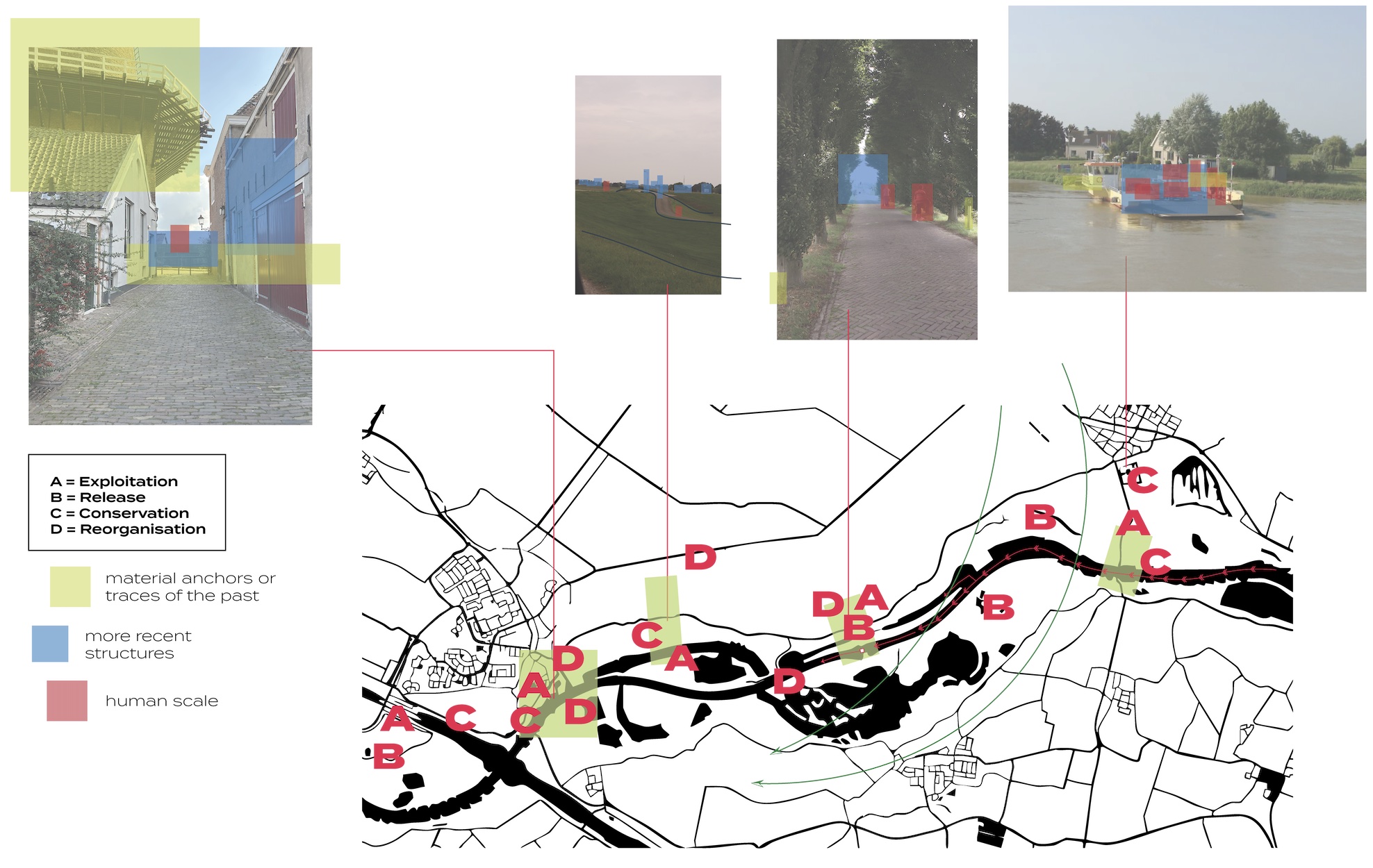
Mapping became the third way of approaching the levee. In Chapter Three, Kilgore’s adaptive cycle was introduced as a way of understanding ecological change through four stages: exploitation, conservation, release and reorganisation.[37]
To bring these stages into a spatial reading, I linked each stage to a letter, following Raoul Bunschoten’s use of A–B–C–D in his maps in Urban Flotsam. His letters are not fixed in specific categories; they are often situational, assigned according to the conditions one wants to isolate. Even so, they often follow a loose pattern: A for the initial forces that set something in motion, B for the moments where tension or disturbance becomes visible, C for patterns of stability, and D (or letters beyond) for the shifts that point toward renewal.[38] Using this pattern, I overlaid Kilgore’s adaptive cycle onto the A–B–C–D frames.
A = Exploitation, showing signs of (re)shaping done in the past.
B = Release, the signs of stress or historical disturbance.
C = Conservation, focusing on what has been stabilised.
D = Reorganisation, framing change and areas currently in movement.
With these letters assigned, I can read the levee through the logic of Kilgore’s adaptive cycle to see where each phase of the cycle becomes visible in the landscape, if it appears at all.
In addition to the use of the letters, I also added these three components to the map:
- A note of material anchors, elaborated on in 5.2
- Lines indicated water and wind direction
- Images of structures of note
The strongest overlaps appeared near the cities themselves, where multiple factors are visible in a small radius. In Wijk bij Duurstede, the walmuur is partuclarly of note. It brings the exploitation, release, and conservation frames together. Its original construction links to early shaping of the landscape, the log with water levens at its entrance, and the cracks and recently patched bricks nod to previous failures and threats of high water, yet its continued presence shows a form of long-term stability. Never did its original shape cease to exist, but it was instead expanded upon.
A comparable situation is happening near the stuwcomplex, where the altered flow of the river, the redirected water’s edge, and the clearly recently added road atop the levee intersect at a single point. This specific intersection shows that there are places where ecological and cultural processes converge, albeit mechanically.
Lastly, the crossing near Amerongen, the ferry point, is an interesting area due to its combination of old and new structures, and its directed flow of movement both by people and by the river: the point of entry of the ferry lies before the Stuwcomplex, making the water‘s changes part of the commute of the inhabitants of the area. The places where these moments or traces overlap are areas in which some sort of structure pulls together influences of people, culture and ecology. In human-made landscapes, the land is pre-determined somehow, it is shaped towards a human logic as opposed to a natural one. Due to this, meeting points aren‘t occuring naturally either, and instead need to be formed along it, which makes the structures that last an acumulation of the past and the present.
5.2 Understanding the landscape through story and culture
Though it is important to do embodied and sensorial research, I am also a person that likes to be thorough and dish my subjectivity with a dollop of objectivity. In part to understand the landscape better, but also to truly tie in the history and cultures surrounding my chosen site – something that is incredibly important when framing landscape memory as a hybrid construct of ecology and culture. Within this chapter, I have touched on many things that I have experienced, but it does often lead me to wonder if these experiences are shared or opposed by others. Even during my walks, which were meant to solely touch on the sensorial, I found myself looking for conversations with strangers I met. I wandered the libraries looking for someone who could tell me about the things I may have overlooked, or possibly something I cannot experience due to the passage of time, and the landscape adjusting along with it.
This section will be dedicated to this comparison I‘m looking for, this conversation with (hi)stories and cultures.
5.2.1 The human experience of the Lek- and Rijndijk
It was significantly harder to find accounts of people’s everyday experience of the levee and the surrounding area. This absence seems to support my hypothesis: the levee is a barricade rather than a threshold, a structure that defines the landscape more than it invites people into it. As a result, very few testimonies appear to be tied to its presence. What I did find was often about disruption. In the newspapers dating back to the 1880s, the levee only received attention when it had broken through or otherwise failed. Most accounts were narrowed down to the reality of loss: water heightened to the roofs of buildings, damages to the roads, evacuation numbers, the cost of rebuilding. These articles show the levee a a place where memory is built around crisis rather than the inhabitants‘ daily life.
There is one recent attempt to capture local experience, and it was conducted ahead of the current reconstruction of the Lekdijk. Over three hundred residents and recreational users were interviewed in Amerongen, Wijk bij Duurstede, and the surrounding area. Their stories rarely focused on the levee as a lived landscape. Instead, most described it through its function: safety, protection and the tragedies of the past. Everyday experiences tended to be about mobility: cycling, driving, walking and the tension between each user of the road atop the levee. When asked directly, only a few participants described an emotional attachment to the levee itself. Most memories surfaced only when tied to high water events, particularly the evacuation of 1995. It was the fear of breakage that seemed to anchor memory to the levee.
During my own fieldwork, I approached several passersby, hoping to find personal stories about the levee. On one of these encounters, I met a woman picking brambles near the Stuwcomplex, where the levee narrows into a tree-lined corridor. We were both startled, since the area had felt empty until we had spotted one another. She explained that she often came here to pick berries and rarely met anyone. Although our conversation was brief, her words told me that the levee functions more as a route than a destination, a place where people pass through rather than a landscape they stay in and attach personal meaning to. Even in this exchange, the levee remained a backdrop. It was not part of our conversation, she was simply happy the municipality had not yet taken down the bushes.
Both of these findings highlight a crucial insight into the levee’s landscape memory. While the structure is central to the region’s safety and history, it remains at the periphery of lived experience. Its memory is shaped by function and tragedy instead of appreciation and attachment. It supports the idea that the levee’s cultural significance goes unseen, while emotional and narrative resonance is carried by the river and its floods.
5.2.2 Using archival pieces to establish a timeline
I visited RAZU, the regional archive situated in Wijk bij duurstede, to establish a timeline of happenings through newspaper and paintings and other artworks. For me, it felt important to understand the adjustments the landscape had experienced, what influenced each change, and how they were spoken of or depicted. It is one thing to understand the current day situation, but another to grasp the influence of its history. Through time, each change affected the culture in the surrounding towns and vice versa. To truly bring into view what landscape memory means in this area, it is a necessity to address the history.
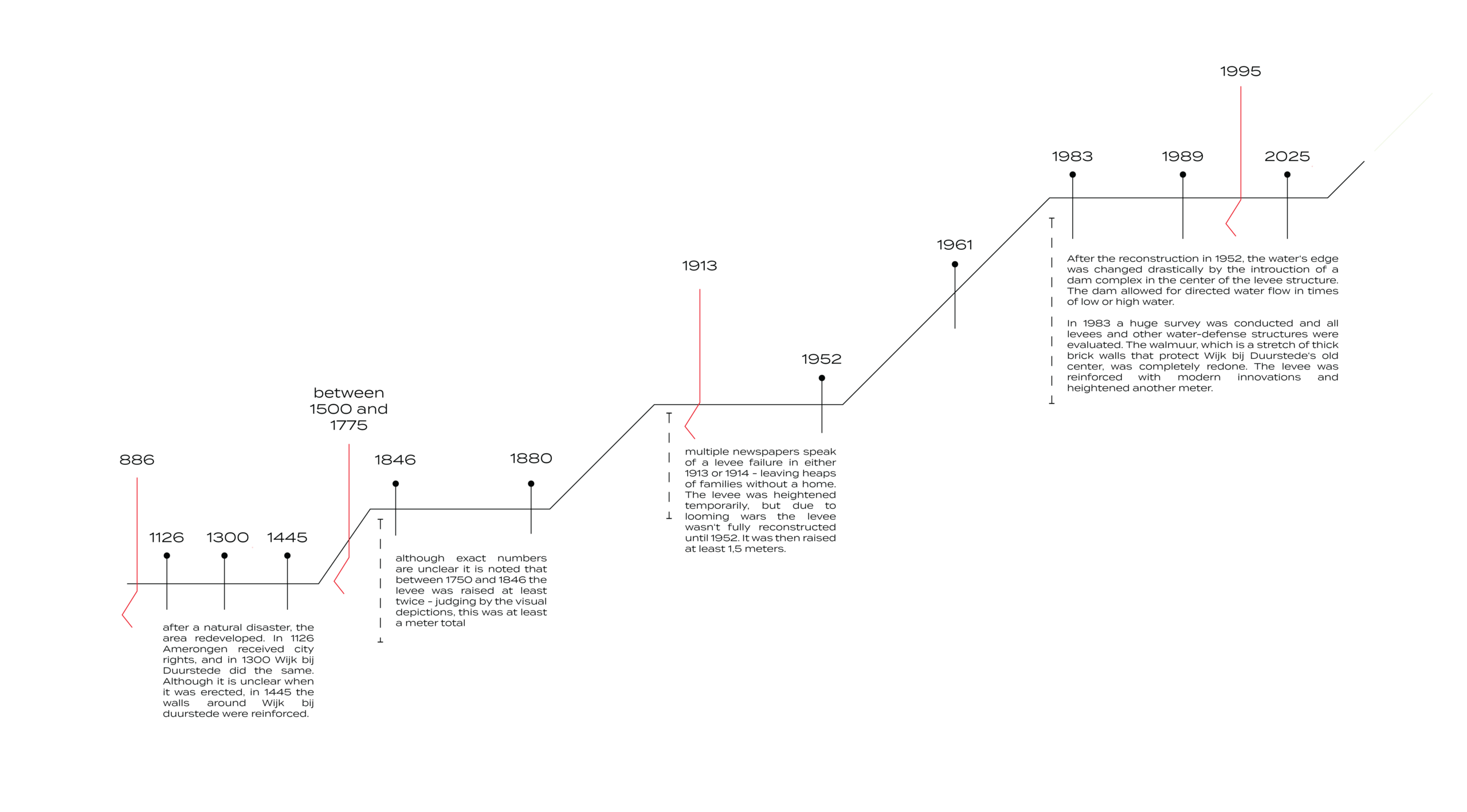
Depicted here is a timeline that shows the pattern of build-up and breakdown I spoke of earlier;
each levee failure, threat of high-water and reconstruction is listed. In 886 some natural disaster happened, though it is unclear what. Afterwards the levee was erected, or at least restored if it was already somewhat present. There were no direct texts, but in a 1163 script, it was mentioned. That same year the Bishop of Amerongen spoke the following words:
“Dat de dam, in den Rijn bij Wijk bij Duurstede, in overoude tijden gelegd, nimmer weggenomen maar altoos in denzelfden staat onderhouden zou worden“
which translates to: “That the Dam, at the Rhine near Wijk bij Duurstede, which was erected long ago, should never be taken away but always be maintained in the state as it is now“
Two Archival pieces highlighted
To create the timeline, I had to anchor myself to certain locations and structures along the levee; The „Veerhuis“ or Ferry house located slightly West of Wijk bij Duurstede, which was rebuilt to fit the new height of the levee. Then the Windmill in Wijk bij duurstede center, which stayed the same over many centuries and embodied the city‘s resilience. Lastly the Stuwcomplex, which was built way later and changed the water‘s edge drastically. Following them through time by following them in paintings helped me ground myself in the location and internally travel through time.
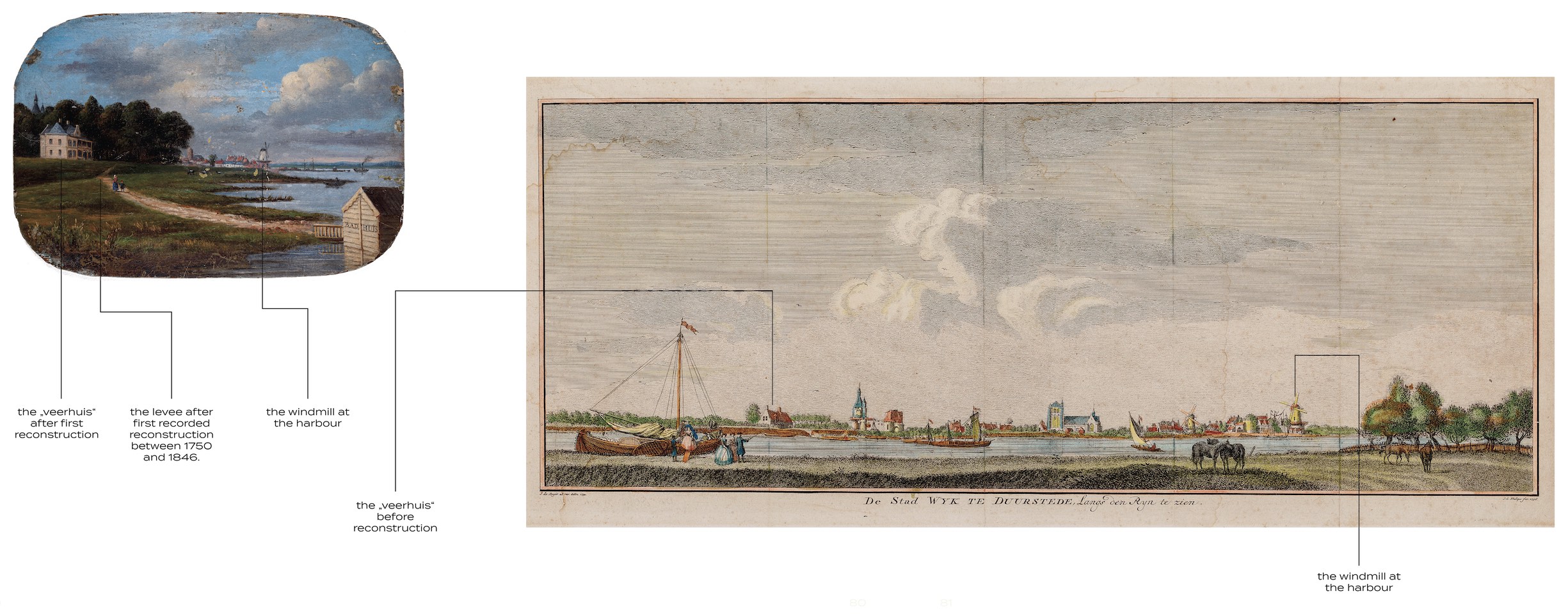
These locations are dubbed „Material Anchors“. Using Material Anchors like this is a great, factual way to get to know a place. They made the levee’s past tangible and allowed me to recognise patterns that are difficult to see when only standing in the present.
5.3 The landscape Memory of the Lek- and Rijndijk
Across all tried methods, the levee kept presenting itself as a landscape continuously reshaped. Its memory is not captured by a single event in time, it instead becomes visible in the ongoing negotiation between the stability and disturbance that defines its existence. When the outcomes are viewed together, there are patterns that perfectly reflect the four stages of Ana Kilgore’s adaptive cycle, showing how the levee remembers through both ecological and cultural processes.
If we look back at each part of the cycle, a clear image can be painted.
Exploitation, or the initial growth, becomes visible in the earliest acts of shaping the land. It is unknown when exactly the levee was constructed, but settlers once claimed ground from the river and redirected its movement intentionally. Later archival pieces show how these settlements lived with this early embankment, and how they changed the face of the riverbank ever so slightly to better meet their needs. The methodical walking helped me see whether this stage is tangible in the present day, But the stage of exploitation has, in my opinion, passed – it is hard to notice new growth or the changes in boundaries, and instead the levee lives in the next stage of conservation.
Conservation is immediately apparent as the levee has entered a new era of reconstruction without the event of a failure triggering it. The road is closed off for most visitors and areas are being dug up to be strenghtened. In chapter three, it was established that conservation is a stage of blockage, something that can be seen in housing blocking the growth of vegetation. Looking closely at the levee now, it becomes clear that conservation is a state of tension, where maintenance isn‘t used to change, but instead improve slightly. The excavations along the slope do not alter the levee’s outline, but strengthen its existing structure. Since no failure happened, there‘s no need to drastically alter its form. By repeatedly writing about the movement and boundaries, it became apparant this stage had been reached. As my father mentioned to me in the opening of this paper, a breakage is inevitable and pre-calculated. In case it happens, and it will, the landscape will enter the stage of Release.
Release only appears in moments when the stability of conservation is broken. A physical reminder of these releases can be found along the levee‘s edge; referring back to Jac. P. Thijsse, there are scars visible if you look close enough. A dent, a secluded pond, a tall pole with record water levels. It is for this reason that the act of mapping caused these reminders to be brought forward as they linger in the landscape well after an event of release, and will always remain far into the next stage of Reoganisation.
Reorganisation can be found in the rebuilding and adjustments that come after the disruption. The ongoing reconstructions that surfaced during my archival deep-dive are a direct example. New materials have been added, old ones are removed, and the landscape is reshaped in response to rising water levels. The timeline I established shows exactly when each phase of reorganisation happened, and the levee carries the acumulation of these responses in its current shape, even when the specific events that caused them have faded from collective memory.
Together, these cycles bring forward a landscape that remembers through continuous negotiation. The levee holds the memory of past floods, reconstructions, and daily interactions, but it also adapts to new challenges. Its memory is both ecological and cultural, able to be felt and seen in the patterns of breakdown and repair. It is an ongoing process at the intersection between water, land, human presence, and the methods used to observe it. These insights allowed me to step back from the levee and compare its behaviour with the patterns found in theory and case studies. This broader comparison is explored in Chapter 6.1, where all research strands are placed alongside one another.
Chapter six: Building a framework of methodologies
6.1 Overlaying of findings of literary, case study and field research
When the findings of the literary review, case studies, and field research are placed alongside one another, a layered image of landscape memory begins to take shape, each building onto one another.
The literary review established that memory in human-made landscapes is carried through ecological processes as well as cultural experience. Chapter 3.1 examined how Dutch human-made landscapes develop through the cycles of shaping, stabilising, disturbance and renewal, drawing from the adaptive cycle to understand how these stages leave traces in the land. Chapter 3.2 focused on cultural memory and showed how collective narratives, historical interventions and everyday practices become part of a landscape’s identity. Chapter 3.3 added a sensorial and embodied layer, explaining how connection develops through attention, presence and repeated encounters. Together, these perspectives described Dutch landscapes as places shaped by adaptation, anticipation and ongoing care.
The case studies offered ways in which these ideas can be translated into built form. At the Moses Bridge, memory becomes perceptible through submersion, through a descent that repositions the body within the historical waterline. At Terp fan de Takomst, memory re-emerges through rhythm, through the tide, and through the act of rising above the landscape while remaining anchored to its heritage. Both sites demonstrate how design can make the layers of a landscape legible by shaping movement, orientation and awareness.
The fieldwork along the Lek- and Rijndijk brought these insights back to the scale of my own lived experience. Through walking, writing, mapping and archival research, different aspects of the levee’s memory surfaced. The methodical walks revealed how the levee directs or restricts movement. The attempts at exhausting the levee showed how everyday life unfolds along its edges and how change becomes visible through small, repeated observations. The mapping brought forward the quieter traces: scars, shifts in water flow, recurring patterns in wind and sound, and the intersections where ecological and cultural processes meet. The archival work and material anchors provided the temporal depth needed to read these traces as part of a longer cycle of shaping, failure, and repair.
When these findings are viewed together, several patterns appear consistently. Time reveals itself through water and its rhythms. Orientation and direction repeatedly guided perception. Thresholds, such as the top and side of the levee, or a descent below the waterline, shaped how the landscape could be sensed. Material anchors grounded memory across centuries, while subtle, often unnoticed elements revealed how the landscape continues to adjust. A final pattern emerged in the invisibility of function. Much of the levee’s significance remains hidden in its operation, its maintenance and its infrastructural labour.
These recurring patterns form the basis for the methodological framework that follows. They show that designing with human-made landscapes requires attention to the temporal, the sensorial, and the historical, and they provide a foundation for the strategies outlined in the next section.
6.2 Toward design strategies for human-made landscape
Taking all that is said and done into account, it is possible to work towards a toolkit for these human-made landscapes, for designers, spatial researchers and other creatives with the intent of working with these landscapes in search of connection. The Lek- and Rijndijk has served as an insightful case study on how landscape memory can be revealed, and it is now time to turn these findings into useful handles for future reference. This toolkit is not intended to be a fixed solution for all human-made landscapes. It instead functions as a set of approaches that can guide attention and support intentional forms of engagement. Each approach originates from patterns that were found across the literary review, case studies and fieldwork. Some focus on temporal behaviour, others on material presence or on the ways movement can shape perception. It is together that they offer a way to read and work with human-made landscapes shaped by water and perpetual human influence. The following methodologies bring these insights into a clear structure that can be adapted to other contexts where human intervention and ecological processes form a shared landscape.
1. Reading Time Through Water
Bodies of water are, of course, a very powerful tool that by themselves influence landscapes heavily. It is the combination of human intervention in these water-altered landscapes that reveal the passage of time. This happens through both natural occurences, such as tides, erosion and seasonal flooding, as well as created situations: sluices, weirs, docks and the directed flow of water by canals and levees. As the human-made landscapes in question often engage with water, it is through this we tell the passage of time differently from simply counting the minutes. Paying attention to seasonal changes, weather conditions and the daily rise and fall of the tides brings forward the ecological patterns that shape human-made landscapes. It allows design to engage with their temporality instead of working against it or finding a work-around. Once there is an understanding of where the water flows when and why, it becomes legible and available for engagement.
2. Locating Material Anchors
Certain structures, like the water, also hold the power to tell time, and it comes in the form of what I call Material Anchors. Locations such as the veerhuis, the windmill and the stuwcomplex became footholds through which the Lek- and Rijndijk‘s history could be read. It was following them through time that gave me deeper insights into the site‘s historical context and allowed for the past, present and future to intersect. Using such anchors could allow designers to work with the acumulation of place: where the layers come together and connect present interventions to their historical context. In short, it is important to locate and identify these Material Anchors to completely understand where to intervene through design.
3. Thresholds of Elevation
Transitional spaces shape experience. Approaches, descents, ascents and other changes in height influence how a landscape is understood from a sensorial perspective. The case studies and my field research showed that shifts in elevation bring forward distinct insights. At the Moses Bridge, the descent below the waterline brought forward historical context. At Terp fan de Takomst, the gradual rise grounded the visitor in place and heritage. On the levee, stepping onto the slope or walking beside it showed different aspects of its identity. I refer to these moments as Thresholds of Elevation. Thresholds of Elevation can be used to prepare visitors, heighten awareness or reveal conditions that remain unnoticed from expected viewpoints. They can guide attention, frame the surrounding landscape or create a moment of reflection. Working with these transitions shows how movement and height shape perception and supports a deeper understanding of the landscape’s underlying logic. Designers and Spatial researchers can use this idea to direct movement and change perspectives within the landscapes they are working with.
4. Cardinal Awareness
Sightlines, cardinal directionality and the horizon offer a way to situate the body in relation to the landscape. Whether it is about obscuring or revealing, framing these orientations can deepen awareness of context and support a stronger connection to place. At Terp fan de Takomst, when given cardinal directions, suddenly this idea of the North being ruled by the sea in the past made complete sense: the water stretched beyond the horizon, and despite the few islands dotted among it, knowing where the water rolled in and out from helped me understand the site better. At the Lek- and Rijndijk, the water of the Rhine rolls by from east to west, something it has always done and always will. Working with cardinal awareness aids designers towards a starting point on where to interject, but also allows for visitors to understand where they are spatially situated.
5. Omnia mutantur, nihil interit
Everything changes but nothing passes; an idea encapsulated within a well-quoted line written by Roman poet Ovidius. It, in essence, touches on something that struck me while on my walks. Where the levee radiated both sturdy and fragile; where my feet were landing atop a strong asphalt road, laid on a structure in need of constant maintenance. It embodies the idea of temporality; Interventions can be placed upon human-made landscapes, entire structures, even those that aid the landscape, but the necessary changes of the site, and its ability to function, dominates all. If a structure needs to be moved for the betterment of the function, it will. Understanding this principle means accepting that nothing within these landscapes is static. Change is a condition of the human-made landscape. It is part of how the landscape expresses its memory, and how it will continue to do so over time. Working with this awareness allows designers and researchers to see human-made landscapes as evolving environments, and to respond to them with approaches that recognise their inherent fluidity.
6. Noticing the (un)subtle
When stood in a place unfamiliar, it is necessary to find what is noticable and what requires attention to notice: Sounds, textures and other patterns are small repetitive signs that can reveal in what ways the landscape is changing. Mapping and writing about these elements can bring forward findings that are otherwise easily overlooked, but also show how they are aligned with what is always present. It is the idea that the same car passes by, but leaves a different print in the soil each time. A similar approach still produces different outcomes, each with its own influence on the landscape. These differences accumulate over time and form a record of how the landscape responds to movement, weather and use. Paying attention to these changes, no matter how subtle, allows designers and researchers to engage with the landscape on a new level; one of timelessness and perpetual change. To illustrate a clear example, the Veerhuis, or ferry house in Wijk bij Duurstede, has been changed in its appearance and height simply to keep up with the changes of the levee. The way this particular building changes in historical paintings, as well as the signs of rebuilding on the sides of the building itself, are all clear marks of this phenomenon: to notice these signs is to be in touch with the memories and changes this landscape is subjected to.
7. Restriction into Speculation
Restriction plays a large role in human-made landscapes. Access is often limited and movement is controlled, which in turn restrains a grasp of complete understanding. Towards the end of my field research parts of the levee could not be reached because of the current reconstruction. The landscape that I had walked before became unreachable, which allowed me only to speculate its going ons. Through earlier observations, historical insights and the logic of the adaptive cycle, it became possible to imagine how certain areas continued to change even when they could no longer be visited, but it was also interesting to think beyond what is known. Speculation is a way to work with this absence. Through speculation, perhaps one could think of future scenarios without adhering to the expectations or set rules. When it comes to the levee, in my writing I thought of how the landscape looked, what they were building beyond what I saw, and whether the edges of the water were drastically changing – but thinking even further could influence design strategies where the usual restrictions of the levee are gone. The outcome may not be realistic of present, but in a landscape ever-adjusting, perhaps they will become feasible later on.
8. Create to Gather
Gathering is a term used in a wide sense, as I intend to include both the gathering of people in one place, as well as the gathering of traces of the past, the present, and changes in general – during my field research, as I started mapping and putting together my thoughts, I realised that the land is pre-determined and follows a human logic as opposed to a natural one. Due to this, meeting points of this kind aren‘t occuring naturally and instead need to follow that same human logic. Previously, I mentioned that the levee is always changing, and therefore things do not last. But those that do last, even when they continue to live on partially, become a Gathering Place of memory both human and landscape. The veerhuis growing with the levee is an example of this, but also the ferry loading dock with layers of fencing and the stuwcomplex where berry bushes persistently grow: human-landscapes are often devoid of places of interaction, unless they are put there intentionally or unintentionally. It is for this reason I suggest to create places to gather, whether intended for human, or non-human gathering, as they will find a way to somehow last through the changes.
These eight methodologies together form the toolkit this research has been aiming for, and are meant to be an answer to my sub-question: What methodological approaches can translate the concept of landscape memory into spatial and architectural ways of working with Dutch human-made landscapes? They are intentionally adaptable: Dutch human-made landscapes, as I‘ve learned, exist in a situational sphere. Not one is the same as the other, despite the overlap of intention; each site carries its own set of conditions, histories, and intersections. What they do share is a recognisable logic of intervention and adaptation. The toolkit responds to that logic by offering ways to notice, analyse, and work with landscape memory. It provides handles that can be adjusted as the context changes. The intention is to support designers and spatial researchers in approaching these landscapes with attentiveness and care, and to open up space for thoughtful engagement.
Chapter seven: Conclusions
7.1 What information has been gained
This research set out to answer the question of how the concept of landscape memory can be translated into spatial and architectural methodologies for Dutch human-made landscapes. Through the combination of literature, theory, case studies and fieldwork, several insights have been gained that contribute to this proposal.
The literary review showed that the Dutch landscape is complex. When looking at human-made landscapes such as polders, levees and terps, they appear defined by continuous cycles of construction, adaptation and maintenance. They carry both ecological and cultural histories, and so it was determined that landscape memory, in the case of Dutch (human-made) landscapes, is not only ecological but should also account for cultural practices, forms of use and everyday interaction. Kilgore’s adaptive cycle supported this reading, and the phases of conservation, release, reorganisation and exploitation were compared to situations occurring in Dutch human-made landscapes.
After this was established, it was important to know how to evoke connection through (architectural) theory; how to tie people to place, especially when it is ever-changing. The case studies demonstrated how spatial interventions can engage with the phases of Kilgore‘s cycle, but also how they suggest methods of connection. The Moses Bridge emphasised the role of directed movement and the approach of a landscape, whereas Terp fan de Takomst highlighted how stories, elevation and orientation can bring long-term practices back into current awareness. Together, they showed how design can make memory legible through sensory engagement.
The field research done at the Lek- and Rijndijk was where the theory was put to practice. All methods chosen for this stage were intended to bring different types of sensorial engagement, coupled with some historical grounding. By walking, writing, mapping, speaking with locals and analysing historical paintings and newspapers, many insights were gained. The walks showed me that the levee directs movement and restricts access, and how breaking the established rules allowed me to meet the river up close. This established the levee as a barrier as opposed to a threshold, as my initial problem statement put forward.
Writing akin to George Perec allowed me to see and notice small and repetitive behaviours, which were useful later on as the access was restricted further due to reconstruction. My first texts fed into my last, and I was able to speculate about the inner workings of the reconstructions. Then, mapping the landscape, in an attempt to grasp Raoul Bunschoten‘s complex maps, was meant to analyse my texts and walks. Through this I was able to find overlaps of phases in the adaptive cycle, where these traces accumulate and could be seen or felt.
Archival research confirmed that these places had rich histories worth digging into, and through following these Material Anchors through the centuries, I was able to establish a timeline that furthered my understanding of the Lek- and Rijndijk. At the end of my field research, I felt like I was part of the landscape simply by being there. Across this combined research, several recurring patterns emerged. Water shapes orientation and time. Height and thresholds influence perception and movement. Material anchors hold onto long-term histories. Small and often unnoticed signs of erosion or scarring reflect the past and future of adaptation.
These insights formed the basis for the methodological framework in Chapter 6.2. The eight approaches draw directly from the patterns identified in theory, case studies and fieldwork, and translate them into spatial and architectural ways of working with human-made landscapes. They outline how designers and spatial researchers can read these environments more closely, recognise their layered histories and work with them as evolving sites.
7.2 Discussion and future outlook
This paper effectively used both a theoretical foundation, as well as practical research to gain insights and work towards a proposal, Reflecting on them both, the goal of putting forward design as a mediator has been reached. But there are, of course, a few limitations. One of those is bias. Most of the embodied field research is inherently biased, as this is based on my personal perceptions of the landscape. Although this is true, certain parts of my methods remained relatively objective. The writing method aimed to simply note what happened in my surroundings without assumption, and the archival research is based on historical fact and existing pieces of art depicting the levee in earlier times. Other than accounting for bias, it is also important to state that this paper focuses only on one specific site. This is mentioned and re-iterated throughout the text. The toolkit presented in Chapter 6.2 is merely that: a toolkit. It is not a fixed solution or a complete answer, but instead a startingpoint that can be altered to fit specified context. Future research could extend this work by applying the toolkit to other Dutch human-made landscapes, such as polders, canals or fortified water defences. Testing the methodologies across multiple sites can show where the patterns identified at the Lek- and Rijndijk reappear and where new ones might emerge. Comparison with other water-based landscapes could provide a broader context for understanding how memory operates in environments shaped by continuous change. Ultimately, this research demonstrates that landscape memory can offer a meaningful basis for working with Dutch human-made landscapes. Understanding how human-made landscapes carry traces of both ecological and cultural processes allows for design approaches that are more connected and aware of change. The toolkit presented here forms a first step in that direction.
Sources
1: Citisens. Waterbewustzijn Onderzoek 2022. Citisens Research Report. The Hague: Citisens, 2022.
2: De Bosatlas van Nederland. Groningen: Noordhoff Uitgevers, 2023. 3: Kilgore, Ana. “How Landscapes Remember.” It’s Freezing in LA! (2024). Accessed January 2, 2025. https://itsfreezinginla.com/articles/landscape-memory
4: Lemaire, Ton. Filosofie van het Landschap. Baarn: Ambo, 1970.
5: Long, Richard. A Line Made by Walking. Photograph. Tate Britain, London, 1967.
6: Observatorium Rotterdam. Observatorium: Public Art and Land Art Projects. Rotterdam: Observatorium, 2018.
7: Pallasmaa, Juhani. The Eyes of the Skin: Architecture and the Senses. 3rd ed. Chichester: Wiley, 2012.
8: Perec, Georges. An Attempt at Exhausting a Place in Paris. Translated by Marc Lowenthal. Cambridge, MA: Wakefield Press, 2010.
9: Rijkswaterstaat. “Dijken.” Accessed August 2025. https://www.rijkswaterstaat.nl/water/waterbeheer/bescherming-tegen-het-water/waterkeringen/dijken
10: Rijkswaterstaat. “Polders.” Accessed June 2025. https://www.rijkswaterstaat.nl/water/waterbeheer/polders
11: Rijkswaterstaat. “Terpen en Wierden.” Accessed August 2025. https://www.rijkswaterstaat.nl/water/waterbeheer/terpen-en-wierden
12: RO&AD Architecten. “Moses Bridge / Loopgraafbrug.” Accessed September 2025. https://ro-ad.org/moses-bridge/
13: Sense of Place. “Terp fan de Takomst.” 2018. Accessed May 2025. https://www.sense-of-place.eu/terp-fan-de-takomst/
14: Thijsse, Jac. P. Onze Groote Rivieren. Amsterdam: P.N. van Kampen & Zoon, 1938.
15: Tuan, Yi-Fu. Space and Place: The Perspective of Experience. Minneapolis: University of Minnesota Press, 1977.
16: Van Dam, Petra J.E.M. “Man Against Water: The History of Water Management in the Netherlands.” Environmental History 15, no. 3 (2010): 759–784.
17: Van de Velde, Mirjam, and Mieke van Dijk. Landschap in de Maak. Rotterdam: nai010 uitgevers, 2010.
18: Wageningen University & Research. Bodemkaart van Nederland – Soorten Bodem en Opbouw. WUR Open Data Portal. Accessed June 2025. https://www.wur.nl/nl/onderzoek-resultaten/onderzoek-instituten/environmental-research/bodemkaart-van-nederland.html
19: Waterschap Rivierenland. Jaarverslag 2022. Tiel: Waterschap Rivierenland, 2023.
[1] Kilgore, Ana. “How Landscapes Remember.” It’s Freezing in LA!, 2024. Accessed January 2, 2025. https://itsfreezinginla.com/articles/landscape-memory.
[2] Mirjam van de Velde and Mieke van Dijk, Landschap in de Maak (Rotterdam: nai010 uitgevers, 2010), 12.
[3] De Bosatlas van Nederland (Groningen: Noordhoff Uitgevers, 2023), 45.
[4] Rijkswaterstaat, “Project Versterking Lekdijk tussen Amerongen en Wijk bij Duurstede,” accessed June 2 2025, https://www.rijkswaterstaat.nl.
[5 Waterschap Rivierenland, Jaarverslag 2022 (Tiel: Waterschap Rivierenland, 2023), 18.
[6] Citisens, Waterbewustzijn Onderzoek 2022 (The Hague: Citisens, 2022).
[7] ibid
[8] Petra J. E. M. van Dam, “Man Against Water: The History of Water Management in the Netherlands,” Environmental History 15, no. 3 (2010): 759.
[9] Petra J. E. M. van Dam, “Man Against Water: The History of Water Management in the Netherlands,” Environmental History 15, no. 3 (2010): 760.
[10] Ana Kilgore, “How Landscapes Remember,” It’s Freezing in LA! (2024), accessed January 2, 2025, https://itsfreezinginla.com/articles/landscape-memory
[11] Richard Long, A Line Made by Walking, 1967, photograph and gelatin silver print, Tate Britain, London.
[12] Georges Perec, An Attempt at Exhausting a Place in Paris, trans. Marc Lowenthal (Cambridge, MA: Wakefield Press, 2010)
[13] Raoul Bunschoten, Urban Flotsam: Stirring the City (Rotterdam: 010 Publishers, 2001)
[14] Mirjam van de Velde and Mieke van Dijk, Landschap in de Maak (Rotterdam: nai010 uitgevers, 2010), 12.
[15] Wageningen University & Research, Bodemkaart van Nederland – Soorten Bodem en Opbouw, WUR Open Data Portal, accessed June 2025, https://www.wur.nl/nl/onderzoek-resultaten/onderzoek-instituten/environmental-research/bodemkaart-van-nederland.htm.
[16] Mirjam van de Velde and Mieke van Dijk, Landschap in de Maak (Rotterdam: nai010 uitgevers, 2010), 12.
[17]Petra J. E. M. van Dam, “Man Against Water: The History of Water Management in the Netherlands,” Environmental History 15, no. 3 (2010): 761.
[18] Jac. P. Thijsse, Onze Groote Rivieren (Amsterdam: P. N. van Kampen & Zoon, 1938), 22.
[19] Ton Lemaire, Filosofie van het Landschap (Baarn: Ambo, 1970), 33.
[20] Rijkswaterstaat, “Terpen en Wierden,” accessed August 2025, https://www.rijkswaterstaat.nl/water/waterbeheer/terpen-en-wierden
[21] Rijkswaterstaat, “Dijken,” accessed August 2025, https://www.rijkswaterstaat.nl/water/waterbeheer/bescherming-tegen-het-water/waterkeringen/dijken
[22] Rijkswaterstaat, “Polders,” accessed June 2025, https://www.rijkswaterstaat.nl/water/waterbeheer/polders
[23] Ana Kilgore, “How Landscapes Remember,” It’s Freezing in LA! (2024), accessed January 2, 2025, https://itsfreezinginla.com/articles/landscape-memory
[24] Ibid
[25] Yi-Fu Tuan, Space and Place: The Perspective of Experience (Minneapolis: University of Minnesota Press, 1977), 6
[26] Juhani Pallasmaa, The Eyes of the Skin: Architecture and the Senses, 3rd ed. (Chichester: Wiley, 2012), 40.
[27] RO&AD Architecten, “Moses Bridge / Loopgraafbrug,” accessed September 2025, https://ro-ad.org/moses-bridge/
[28] Ibid.
[29] Observatorium, Observatorium: Public Art for Public Life (Rotterdam: nai010 publishers, 20
[30] Terp fan de Takomst,” Sense of Place, accessed May 2025, https://www.sense-of-place.eu/terp-fan-de-takomst/18)
[31] Ibid.
[32] Juhani Pallasmaa, The Eyes of the Skin: Architecture and the Senses, 3rd ed. (Chichester: Wiley, 2012), 40.
[33] Richard Long, A Line Made by Walking, 1967, photograph and gelatin silver print, Tate Britain, London.
[34] Georges Perec, An Attempt at Exhausting a Place in Paris, trans. Marc Lowenthal (Cambridge, MA: Wakefield Press, 2010), 29.
[35] Georges Perec, An Attempt at Exhausting a Place in Paris, trans. Marc Lowenthal (Cambridge, MA: Wakefield Press, 2010), 29.
[36] Raoul Bunschoten, Urban Flotsam: Stirring the City (Rotterdam: 010 Publishers, 2001).
[37] ibid.
[38] Ana Kilgore, “How Landscapes Remember,” It’s Freezing in LA! (2024), accessed January 2, 2025, https://itsfreezinginla.com/articles/landscape-memory
[39] Raoul Bunschoten, Urban Flotsam: Stirring the City (Rotterdam: 010 Publishers, 2001).